Charmey geodata
Charmey (Fribourg) is a populated place; located in Switzerland in Europe/Zurich (GMT+2) time zone. With population of 1,713 people, there are 942 cities with bigger population in this country. Compared to other cities in Switzerland, 81.4% of cities are located further ↑North; 82.7% of cities are located further →East and 92.3% of cities have lower elevation than Charmey. Note1


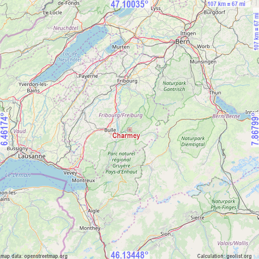
Charmey GPS coordinates[2]
46° 37' 10.452" North, 7° 9' 53.496" East
| Map corner | latitude | longitude |
|---|---|---|
| Upper-left | 47.10035°, | 6.46174° |
| Center: | 46.61957°, | 7.16486° |
| Lower-right: | 46.13448°, | 7.86799° |
| Map W x H: | 107.4×107.4 km | = 66.7×66.7mi |
| max Lat: | 47.76737° ⇑81.4% North |
| Charmey: | 46.61957° |
| min Lat: | ⇓18.6% South 45.83203° |
| min Long | Charmey | max Long |
| 5.97153° | 7.16486° | 10.44624° |
| W 17.3%⇐ | ⇒82.7% E |
Elevation
Elevation of Charmey is 895 m = 2936 ft, and this is 336.8 m = 1105 ft above average elevation for this country.
| Max E: |
1845 m = 6053 ft | 7.7% |
| Charmey | 895 m 2936 ft | |
| Avg. | 558.2 m = 1831 ft | |
Min E: |
197 m = 646 ft | 92.3% |
See also: Switzerland elevation on elevation.city.
Geographical zone
Charmey is located in North temperate zone (between Tropic of Cancer and the Arctic Circle). Distance of this North polar circle is 2217.6 km =1378 mi to North.| Distance of | km | miles | from Charmey |
|---|---|---|---|
| North Pole | 4823.5 | 2997.2 | to North |
| Arctic Circle | 2217.6 | 1378 | to North |
| Tropic Cancer | 2577.7 | 1601.7 | to South |
| Equator | 5183.6 | 3220.9 | to South |


Nearby cities:
15 places around Charmey: (largest is in red/bold)
• Broc
5.3 km =3.3 mi,  252°
252°
• Bulle
8.2 km =5.1 mi,  268°
268°
• Enney
8.5 km =5.3 mi,  226°
226°
• Grandvillard
10.8 km =6.7 mi,  214°
214°
• Gruyères
7.5 km =4.7 mi,  237°
237°
• Hauteville
7 km =4.3 mi,  323°
323°
• Jaun
8.5 km =5.3 mi,  96°
96°
• La Roche
8.8 km =5.5 mi,  346°
346°
• La Tour-de-Trême
7.7 km =4.8 mi,  262°
262°
• Marsens
9 km =5.6 mi,  297°
297°
• Pont-la-Ville
9.6 km =6 mi,  334°
334°
• Riaz
8.3 km =5.2 mi,  287°
287°
• Sorens
10.2 km =6.3 mi, 302°
• Treyvaux
12.2 km =7.6 mi, 350°
• Vuadens
11.3 km =7 mi, 267°
Sources, notices
• [Note1] Compared only with cities in Switzerland existing in our database
• [Src1] Map data: © OpenStreetMap contributors (CC-BY-SA)
• [Src2] Other city data from geonames.org with taken over terms of usage.
• [Src3] Geographical zone / Annual Mean Temperature by Robert A. Rohde @ Wikipedia
