Bad Ragaz geodata
Bad Ragaz (Saint Gallen) is a populated place; located in Switzerland in Europe/Zurich (GMT+2) time zone. With population of 5,063 people, there are 337 cities with bigger population in this country. Compared to other cities in Switzerland, 64.2% of cities are located further ↑North; 96.7% of cities are located further ←West and 58.8% of cities have lower elevation than Bad Ragaz. Note1
Administrative division(s):
- Level 1: Saint Gallen
- Level 2: Wahlkreis Sarganserland
- Level 3: Bad Ragaz


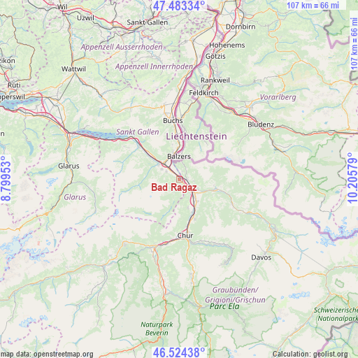
Bad Ragaz GPS coordinates[2]
47° 0' 21.636" North, 9° 30' 9.576" East
| Map corner | latitude | longitude |
|---|---|---|
| Upper-left | 47.48334°, | 8.79953° |
| Center: | 47.00601°, | 9.50266° |
| Lower-right: | 46.52438°, | 10.20579° |
| Map W x H: | 106.6×106.6 km | = 66.2×66.2mi |
| max Lat: | 47.76737° ⇑64.2% North |
| Bad Ragaz: | 47.00601° |
| min Lat: | ⇓35.8% South 45.83203° |
| min Long | Bad Ragaz | max Long |
| 5.97153° | 9.50266° | 10.44624° |
| W 96.7%⇐ | ⇒3.3% E |
Elevation
Elevation of Bad Ragaz is 512 m = 1680 ft, and this is 46.2 m = 152 ft below average elevation for this country.
| Max E: |
1845 m = 6053 ft | 41.2% |
| Avg. | 558.2 m = 1831 ft | |
| Bad Ragaz | 512 m = 1680 ft | |
Min E: |
197 m = 646 ft | 58.8% |
See also: Switzerland elevation on elevation.city.
Geographical zone
Bad Ragaz is located in North temperate zone (between Tropic of Cancer and the Arctic Circle). Distance of this North polar circle is 2174.6 km =1351.2 mi to North.| Distance of | km | miles | from Bad Ragaz |
|---|---|---|---|
| North Pole | 4780.5 | 2970.5 | to North |
| Arctic Circle | 2174.6 | 1351.2 | to North |
| Tropic Cancer | 2620.7 | 1628.4 | to South |
| Equator | 5226.6 | 3247.7 | to South |


Nearby cities:
15 places around Bad Ragaz: (largest is in red/bold)
• Fläsch
2.3 km =1.4 mi,  20°
20°
• Grüsch
11.3 km =7 mi,  105°
105°
• Haldenstein
14.3 km =8.9 mi,  172°
172°
• Igis
8.6 km =5.3 mi,  141°
141°
• Jenins
4.1 km =2.5 mi,  97°
97°
• Landquart
7.9 km =4.9 mi, 142°
• Maienfeld
2.2 km =1.4 mi,  93°
93°
• Malans
6.2 km =3.9 mi,  116°
116°
• Mastrils
5.1 km =3.2 mi, 141°
• Röfels
3.2 km =2 mi,  82°
82°
• Sargans
6.7 km =4.2 mi,  315°
315°
• Sevelen
13 km =8.1 mi,  354°
354°
• Trimmis
12.5 km =7.8 mi,  159°
159°
• Untervaz
9.1 km =5.7 mi, 164°
• Zizers
9.1 km =5.7 mi,  148°
148°
Sources, notices
• [Note1] Compared only with cities in Switzerland existing in our database
• [Src1] Map data: © OpenStreetMap contributors (CC-BY-SA)
• [Src2] Other city data from geonames.org with taken over terms of usage.
• [Src3] Geographical zone / Annual Mean Temperature by Robert A. Rohde @ Wikipedia
