Sevelen geodata
Sevelen (Saint Gallen) is a populated place; located in Switzerland in Europe/Zurich (GMT+2) time zone. With population of 4,392 people, there are 396 cities with bigger population in this country. Compared to other cities in Switzerland, 57.9% of cities are located further ↑North; 96.5% of cities are located further ←West and 56.6% of cities have higher elevation than Sevelen. Note1


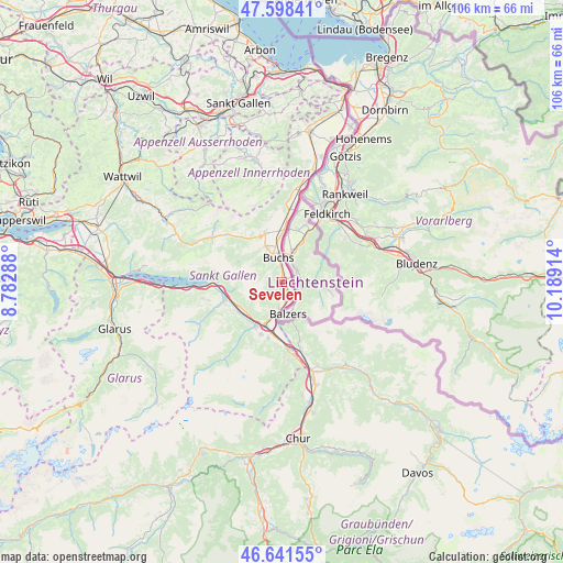
Sevelen GPS coordinates[2]
47° 7' 19.668" North, 9° 29' 9.636" East
| Map corner | latitude | longitude |
|---|---|---|
| Upper-left | 47.59841°, | 8.78288° |
| Center: | 47.12213°, | 9.48601° |
| Lower-right: | 46.64155°, | 10.18914° |
| Map W x H: | 106.4×106.4 km | = 66.1×66.1mi |
| max Lat: | 47.76737° ⇑57.9% North |
| Sevelen: | 47.12213° |
| min Lat: | ⇓42.1% South 45.83203° |
| min Long | Sevelen | max Long |
| 5.97153° | 9.48601° | 10.44624° |
| W 96.5%⇐ | ⇒3.5% E |
Elevation
Elevation of Sevelen is 463 m = 1519 ft, and this is 95.2 m = 312 ft below average elevation for this country.
| Max E: |
1845 m = 6053 ft | 56.6% |
| Avg. | 558.2 m = 1831 ft | |
| Sevelen | 463 m = 1519 ft | |
Min E: |
197 m = 646 ft | 43.4% |
See also: Switzerland elevation on elevation.city.
Geographical zone
Sevelen is located in North temperate zone (between Tropic of Cancer and the Arctic Circle). Distance of this North polar circle is 2161.7 km =1343.2 mi to North.| Distance of | km | miles | from Sevelen |
|---|---|---|---|
| North Pole | 4767.6 | 2962.4 | to North |
| Arctic Circle | 2161.7 | 1343.2 | to North |
| Tropic Cancer | 2633.6 | 1636.4 | to South |
| Equator | 5239.5 | 3255.7 | to South |


Nearby cities:
15 places around Sevelen: (largest is in red/bold)
• Bad Ragaz
13 km =8.1 mi,  174°
174°
• Buchs
5.1 km =3.2 mi,  353°
353°
• Flums
11.4 km =7.1 mi,  252°
252°
• Fläsch
10.9 km =6.8 mi, 168°
• Gams
9.7 km =6 mi,  339°
339°
• Grabs
7.4 km =4.6 mi,  334°
334°
• Haag (Rheintal)
9.8 km =6.1 mi,  1°
1°
• Jenins
14.4 km =8.9 mi,  158°
158°
• Maienfeld
13.5 km =8.4 mi, 165°
• Röfels
13.2 km =8.2 mi, 160°
• Sargans
8.8 km =5.5 mi,  202°
202°
• Sennwald
15.5 km =9.6 mi, 4°
• Unterwasser
15.8 km =9.8 mi,  301°
301°
• Walenstadt
13.2 km =8.2 mi,  270°
270°
• Wildhaus
13.6 km =8.5 mi,  313°
313°
Sources, notices
• [Note1] Compared only with cities in Switzerland existing in our database
• [Src1] Map data: © OpenStreetMap contributors (CC-BY-SA)
• [Src2] Other city data from geonames.org with taken over terms of usage.
• [Src3] Geographical zone / Annual Mean Temperature by Robert A. Rohde @ Wikipedia
