Adligenswil geodata
Adligenswil (Lucerne) is a populated place; located in Switzerland in Europe/Zurich (GMT+2) time zone. With population of 5,576 people, there are 298 cities with bigger population in this country. Compared to other cities in Switzerland, 60.7% of cities are located further ↑North; 51.9% of cities are located further →East and 65.1% of cities have lower elevation than Adligenswil. Note1


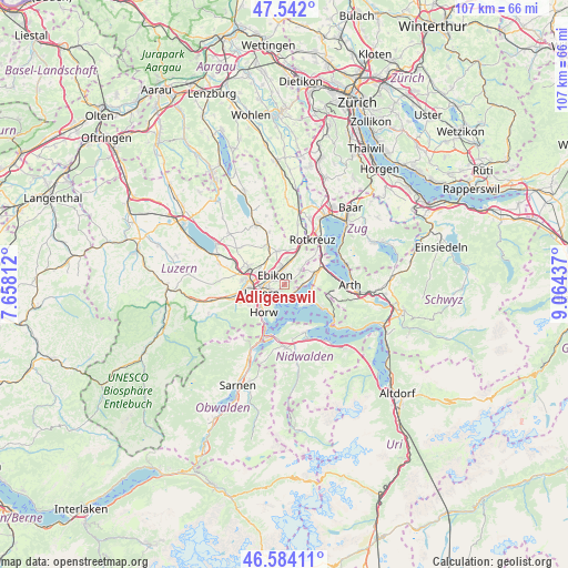
Adligenswil GPS coordinates[2]
47° 3' 54.756" North, 8° 21' 40.464" East
| Map corner | latitude | longitude |
|---|---|---|
| Upper-left | 47.542°, | 7.65812° |
| Center: | 47.06521°, | 8.36124° |
| Lower-right: | 46.58411°, | 9.06437° |
| Map W x H: | 106.5×106.5 km | = 66.2×66.2mi |
| max Lat: | 47.76737° ⇑60.7% North |
| Adligenswil: | 47.06521° |
| min Lat: | ⇓39.3% South 45.83203° |
| min Long | Adligenswil | max Long |
| 5.97153° | 8.36124° | 10.44624° |
| W 48.1%⇐ | ⇒51.9% E |
Elevation
Elevation of Adligenswil is 547 m = 1795 ft, and this is 11.2 m = 37 ft below average elevation for this country.
| Max E: |
1845 m = 6053 ft | 34.9% |
| Avg. | 558.2 m = 1831 ft | |
| Adligenswil | 547 m = 1795 ft | |
Min E: |
197 m = 646 ft | 65.1% |
See also: Switzerland elevation on elevation.city.
Geographical zone
Adligenswil is located in North temperate zone (between Tropic of Cancer and the Arctic Circle). Distance of this North polar circle is 2168 km =1347.1 mi to North.| Distance of | km | miles | from Adligenswil |
|---|---|---|---|
| North Pole | 4773.9 | 2966.4 | to North |
| Arctic Circle | 2168 | 1347.1 | to North |
| Tropic Cancer | 2627.2 | 1632.5 | to South |
| Equator | 5233.2 | 3251.8 | to South |


Nearby cities:
15 places around Adligenswil: (largest is in red/bold)
• Buchrain
3.6 km =2.2 mi,  342°
342°
• Ebikon
2.2 km =1.4 mi,  314°
314°
• Emmen
6.8 km =4.2 mi,  282°
282°
• Greppen
5.3 km =3.3 mi,  103°
103°
• Horw
6.6 km =4.1 mi,  216°
216°
• Inwil
6.7 km =4.2 mi,  352°
352°
• Kriens
6.9 km =4.3 mi,  236°
236°
• Küssnacht
6.5 km =4 mi,  69°
69°
• Littau
7.7 km =4.8 mi,  257°
257°
• Luzern
4.5 km =2.8 mi,  248°
248°
• Meggen
2.3 km =1.4 mi,  153°
153°
• Meierskappel
9 km =5.6 mi,  43°
43°
• Root
5.9 km =3.7 mi,  21°
21°
• Udligenswil
4.2 km =2.6 mi,  49°
49°
• Weggis
6.5 km =4 mi,  124°
124°
Sources, notices
• [Note1] Compared only with cities in Switzerland existing in our database
• [Src1] Map data: © OpenStreetMap contributors (CC-BY-SA)
• [Src2] Other city data from geonames.org with taken over terms of usage.
• [Src3] Geographical zone / Annual Mean Temperature by Robert A. Rohde @ Wikipedia
