Hinteregg geodata
Hinteregg (Zurich) is a populated place; located in Switzerland in Europe/Zurich (GMT+2) time zone. With population of 1,107 people, there are 1261 cities with bigger population in this country. Compared to other cities in Switzerland, 59% of cities are located further ↓South; 73% of cities are located further ←West and 68.1% of cities have lower elevation than Hinteregg. Note1


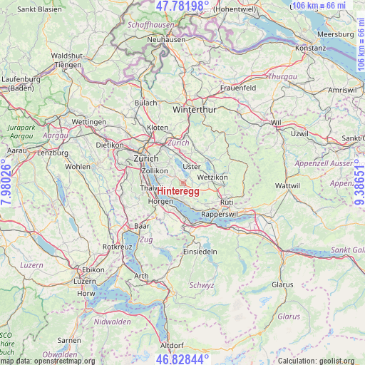
Hinteregg GPS coordinates[2]
47° 18' 26.496" North, 8° 41' 0.204" East
| Map corner | latitude | longitude |
|---|---|---|
| Upper-left | 47.78198°, | 7.98026° |
| Center: | 47.30736°, | 8.68339° |
| Lower-right: | 46.82844°, | 9.38651° |
| Map W x H: | 106×106 km | = 65.9×65.9mi |
| max Lat: | 47.76737° ⇑41% North |
| Hinteregg: | 47.30736° |
| min Lat: | ⇓59% South 45.83203° |
| min Long | Hinteregg | max Long |
| 5.97153° | 8.68339° | 10.44624° |
| W 73%⇐ | ⇒27% E |
Elevation
Elevation of Hinteregg is 563 m = 1847 ft, and this is 4.8 m = 16 ft above average elevation for this country.
| Max E: |
1845 m = 6053 ft | 31.9% |
| Hinteregg | 563 m 1847 ft | |
| Avg. | 558.2 m = 1831 ft | |
Min E: |
197 m = 646 ft | 68.1% |
See also: Switzerland elevation on elevation.city.
Geographical zone
Hinteregg is located in North temperate zone (between Tropic of Cancer and the Arctic Circle). Distance of this North polar circle is 2141.1 km =1330.4 mi to North.| Distance of | km | miles | from Hinteregg |
|---|---|---|---|
| North Pole | 4747 | 2949.6 | to North |
| Arctic Circle | 2141.1 | 1330.4 | to North |
| Tropic Cancer | 2654.2 | 1649.2 | to South |
| Equator | 5260.1 | 3268.5 | to South |


Nearby cities:
15 places around Hinteregg: (largest is in red/bold)
• Aesch
3.3 km =2.1 mi,  318°
318°
• Egg
1 km =0.6 mi,  148°
148°
• Esslingen
3.4 km =2.1 mi,  142°
142°
• Meilen
4.8 km =3 mi,  215°
215°
• Meilen / Halten
4.6 km =2.9 mi,  206°
206°
• Mönchaltorf
2.8 km =1.7 mi,  84°
84°
• Mönchaltorf / Dorf
2.9 km =1.8 mi,  97°
97°
• Mönchaltorf / Hohfurren
2.8 km =1.7 mi,  71°
71°
• Oetwil / Zelgliacker
4.7 km =2.9 mi, 143°
• Riedikon
3.5 km =2.2 mi,  39°
39°
• Scheuren
2.6 km =1.6 mi, 316°
• Uetikon
4.8 km =3 mi,  183°
183°
• Uetikon / Chlidorf
4.8 km =3 mi, 180°
• Uetikon / Grossdorf
4.6 km =2.9 mi,  185°
185°
• Uster / Nieder-Uster
4.6 km =2.9 mi,  16°
16°
Sources, notices
• [Note1] Compared only with cities in Switzerland existing in our database
• [Src1] Map data: © OpenStreetMap contributors (CC-BY-SA)
• [Src2] Other city data from geonames.org with taken over terms of usage.
• [Src3] Geographical zone / Annual Mean Temperature by Robert A. Rohde @ Wikipedia
