Mönchaltorf / Dorf geodata
Mönchaltorf / Dorf (Zurich) is a section of populated place; located in Switzerland in Europe/Zurich (GMT+2) time zone. With population of 1,077 people, there are 1277 cities with bigger population in this country. Compared to other cities in Switzerland, 58.6% of cities are located further ↓South; 76.4% of cities are located further ←West and 65.3% of cities have higher elevation than Mönchaltorf / Dorf. Note1


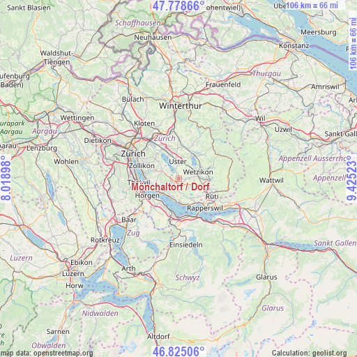
Mönchaltorf / Dorf GPS coordinates[2]
47° 18' 14.436" North, 8° 43' 19.596" East
| Map corner | latitude | longitude |
|---|---|---|
| Upper-left | 47.77866°, | 8.01898° |
| Center: | 47.30401°, | 8.72211° |
| Lower-right: | 46.82506°, | 9.42523° |
| Map W x H: | 106×106 km | = 65.9×65.9mi |
| max Lat: | 47.76737° ⇑41.4% North |
| Mönchaltorf / Dorf: | 47.30401° |
| min Lat: | ⇓58.6% South 45.83203° |
| min Long | Mönchaltorf / | max Long |
| 5.97153° | 8.72211° | 10.44624° |
| W 76.4%⇐ | ⇒23.6% E |
Elevation
Elevation of Mönchaltorf / Dorf is 446 m = 1463 ft, and this is 112.2 m = 368 ft below average elevation for this country.
| Max E: |
1845 m = 6053 ft | 65.3% |
| Avg. | 558.2 m = 1831 ft | |
| Mönchaltorf / Dorf | 446 m = 1463 ft | |
Min E: |
197 m = 646 ft | 34.7% |
See also: Switzerland elevation on elevation.city.
Geographical zone
Mönchaltorf / Dorf is located in North temperate zone (between Tropic of Cancer and the Arctic Circle). Distance of this North polar circle is 2141.5 km =1330.7 mi to North.| Distance of | km | miles | from Mönchaltorf / Dorf |
|---|---|---|---|
| North Pole | 4747.3 | 2949.8 | to North |
| Arctic Circle | 2141.5 | 1330.7 | to North |
| Tropic Cancer | 2653.8 | 1649 | to South |
| Equator | 5259.7 | 3268.2 | to South |


Nearby cities:
15 places around Mönchaltorf / Dorf: (largest is in red/bold)
• Bertschikon
3.2 km =2 mi,  56°
56°
• Binzikon
4.1 km =2.5 mi,  138°
138°
• Egg
2.4 km =1.5 mi,  258°
258°
• Esslingen
2.5 km =1.6 mi,  200°
200°
• Gossau
2.7 km =1.7 mi,  87°
87°
• Grüt
4.7 km =2.9 mi,  79°
79°
• Hinteregg
2.9 km =1.8 mi,  277°
277°
• Mönchaltorf
0.6 km =0.4 mi,  347°
347°
• Mönchaltorf / Hohfurren
1.3 km =0.8 mi, 347°
• Oetwil
3.7 km =2.3 mi,  182°
182°
• Oetwil / Vogelsang
4.2 km =2.6 mi,  174°
174°
• Oetwil / Zelgliacker
3.4 km =2.1 mi, 181°
• Riedikon
3.2 km =2 mi, 346°
• Uster / Kirch-Uster
4.7 km =2.9 mi,  356°
356°
• Uster / Nossikon
4.1 km =2.5 mi,  3°
3°
Sources, notices
• [Note1] Compared only with cities in Switzerland existing in our database
• [Src1] Map data: © OpenStreetMap contributors (CC-BY-SA)
• [Src2] Other city data from geonames.org with taken over terms of usage.
• [Src3] Geographical zone / Annual Mean Temperature by Robert A. Rohde @ Wikipedia
