Mönchaltorf geodata
Mönchaltorf (Zurich) is a populated place; located in Switzerland in Europe/Zurich (GMT+2) time zone. With population of 2,779 people, there are 636 cities with bigger population in this country. Compared to other cities in Switzerland, 59.1% of cities are located further ↓South; 76.2% of cities are located further ←West and 65.9% of cities have higher elevation than Mönchaltorf. Note1


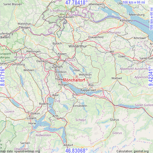
Mönchaltorf GPS coordinates[2]
47° 18' 34.488" North, 8° 43' 13.044" East
| Map corner | latitude | longitude |
|---|---|---|
| Upper-left | 47.78418°, | 8.01716° |
| Center: | 47.30958°, | 8.72029° |
| Lower-right: | 46.83068°, | 9.42341° |
| Map W x H: | 106×106 km | = 65.9×65.9mi |
| max Lat: | 47.76737° ⇑40.9% North |
| Mönchaltorf: | 47.30958° |
| min Lat: | ⇓59.1% South 45.83203° |
| min Long | Mönchaltorf | max Long |
| 5.97153° | 8.72029° | 10.44624° |
| W 76.2%⇐ | ⇒23.8% E |
Elevation
Elevation of Mönchaltorf is 445 m = 1460 ft, and this is 113.2 m = 371 ft below average elevation for this country.
| Max E: |
1845 m = 6053 ft | 65.9% |
| Avg. | 558.2 m = 1831 ft | |
| Mönchaltorf | 445 m = 1460 ft | |
Min E: |
197 m = 646 ft | 34.1% |
See also: Switzerland elevation on elevation.city.
Geographical zone
Mönchaltorf is located in North temperate zone (between Tropic of Cancer and the Arctic Circle). Distance of this North polar circle is 2140.8 km =1330.2 mi to North.| Distance of | km | miles | from Mönchaltorf |
|---|---|---|---|
| North Pole | 4746.7 | 2949.5 | to North |
| Arctic Circle | 2140.8 | 1330.2 | to North |
| Tropic Cancer | 2654.4 | 1649.4 | to South |
| Equator | 5260.3 | 3268.6 | to South |


Nearby cities:
15 places around Mönchaltorf: (largest is in red/bold)
• Bertschikon
3.1 km =1.9 mi,  67°
67°
• Egg
2.5 km =1.6 mi,  244°
244°
• Esslingen
3 km =1.9 mi,  194°
194°
• Gossau
2.9 km =1.8 mi,  99°
99°
• Hinteregg
2.8 km =1.7 mi,  264°
264°
• Mönchaltorf / Dorf
0.6 km =0.4 mi,  167°
167°
• Mönchaltorf / Hohfurren
0.7 km =0.4 mi,  346°
346°
• Oetwil
4.3 km =2.7 mi,  180°
180°
• Oetwil / Zelgliacker
4 km =2.5 mi, 179°
• Riedikon
2.5 km =1.6 mi, 346°
• Uster
4.2 km =2.6 mi,  0°
0°
• Uster / Kirch-Uster
4 km =2.5 mi,  357°
357°
• Uster / Nieder-Uster
4.5 km =2.8 mi,  340°
340°
• Uster / Nossikon
3.5 km =2.2 mi,  6°
6°
• Uster / Ober-Uster
4.5 km =2.8 mi, 12°
Sources, notices
• [Note1] Compared only with cities in Switzerland existing in our database
• [Src1] Map data: © OpenStreetMap contributors (CC-BY-SA)
• [Src2] Other city data from geonames.org with taken over terms of usage.
• [Src3] Geographical zone / Annual Mean Temperature by Robert A. Rohde @ Wikipedia
