Dietikon / Unterdorf geodata
Dietikon / Unterdorf (Zurich) is a section of populated place; located in Switzerland in Europe/Zurich (GMT+2) time zone. With population of 748 people, there are 1540 cities with bigger population in this country. Compared to other cities in Switzerland, 74.8% of cities are located further ↓South; 50.1% of cities are located further ←West and 91.5% of cities have higher elevation than Dietikon / Unterdorf. Note1


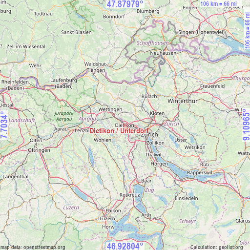
Dietikon / Unterdorf GPS coordinates[2]
47° 24' 21.816" North, 8° 24' 23.472" East
| Map corner | latitude | longitude |
|---|---|---|
| Upper-left | 47.87979°, | 7.7034° |
| Center: | 47.40606°, | 8.40652° |
| Lower-right: | 46.92804°, | 9.10965° |
| Map W x H: | 105.8×105.8 km | = 65.7×65.7mi |
| max Lat: | 47.76737° ⇑25.2% North |
| Dietikon / Unterdorf: | 47.40606° |
| min Lat: | ⇓74.8% South 45.83203° |
| min Long | Dietikon / Unte | max Long |
| 5.97153° | 8.40652° | 10.44624° |
| W 50.1%⇐ | ⇒49.9% E |
Elevation
Elevation of Dietikon / Unterdorf is 388 m = 1273 ft, and this is 170.2 m = 558 ft below average elevation for this country.
| Max E: |
1845 m = 6053 ft | 91.5% |
| Avg. | 558.2 m = 1831 ft | |
| Dietikon / Unterdorf | 388 m = 1273 ft | |
Min E: |
197 m = 646 ft | 8.5% |
See also: Switzerland elevation on elevation.city.
Geographical zone
Dietikon / Unterdorf is located in North temperate zone (between Tropic of Cancer and the Arctic Circle). Distance of this North polar circle is 2130.1 km =1323.6 mi to North.| Distance of | km | miles | from Dietikon / Unterdorf |
|---|---|---|---|
| North Pole | 4736 | 2942.8 | to North |
| Arctic Circle | 2130.1 | 1323.6 | to North |
| Tropic Cancer | 2665.1 | 1656 | to South |
| Equator | 5271.1 | 3275.3 | to South |


Nearby cities:
15 places around Dietikon / Unterdorf: (largest is in red/bold)
• Dietikon
0.7 km =0.4 mi,  224°
224°
• Dietikon / Almend
1.1 km =0.7 mi,  262°
262°
• Dietikon / Fondli
1.5 km =0.9 mi,  280°
280°
• Dietikon / Guggenbühl
0.7 km =0.4 mi,  169°
169°
• Dietikon / Hofacker
1.2 km =0.7 mi,  143°
143°
• Dietikon / Kreuzacker
0.9 km =0.6 mi,  206°
206°
• Dietikon / Oberdorf
1.1 km =0.7 mi,  237°
237°
• Dietikon / Rütematt
1.4 km =0.9 mi,  196°
196°
• Dietikon / Vorstadt
0.7 km =0.4 mi,  288°
288°
• Fahrweid (nördl. Teil)
1.1 km =0.7 mi,  34°
34°
• Fahrweid (nördl. Teil) / Fahrweid
0.9 km =0.6 mi,  47°
47°
• Fahrweid (südl. Teil)
0.6 km =0.4 mi,  66°
66°
• Geroldswil
1.8 km =1.1 mi,  10°
10°
• Geroldswil / Haslern
1.8 km =1.1 mi,  24°
24°
• Geroldswil / Huebwiesen
1.8 km =1.1 mi, 6°
Sources, notices
• [Note1] Compared only with cities in Switzerland existing in our database
• [Src1] Map data: © OpenStreetMap contributors (CC-BY-SA)
• [Src2] Other city data from geonames.org with taken over terms of usage.
• [Src3] Geographical zone / Annual Mean Temperature by Robert A. Rohde @ Wikipedia
