Dietikon / Oberdorf geodata
Dietikon / Oberdorf (Zurich) is a section of populated place; located in Switzerland in Europe/Zurich (GMT+2) time zone. With population of 4,147 people, there are 420 cities with bigger population in this country. Compared to other cities in Switzerland, 73.8% of cities are located further ↓South; 50.6% of cities are located further →East and 85.9% of cities have higher elevation than Dietikon / Oberdorf. Note1


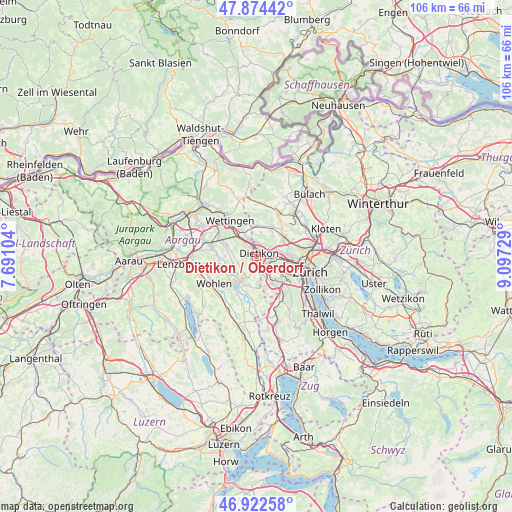
Dietikon / Oberdorf GPS coordinates[2]
47° 24' 2.34" North, 8° 23' 38.976" East
| Map corner | latitude | longitude |
|---|---|---|
| Upper-left | 47.87442°, | 7.69104° |
| Center: | 47.40065°, | 8.39416° |
| Lower-right: | 46.92258°, | 9.09729° |
| Map W x H: | 105.8×105.8 km | = 65.7×65.7mi |
| max Lat: | 47.76737° ⇑26.2% North |
| Dietikon / Oberdorf: | 47.40065° |
| min Lat: | ⇓73.8% South 45.83203° |
| min Long | Dietikon / Ober | max Long |
| 5.97153° | 8.39416° | 10.44624° |
| W 49.4%⇐ | ⇒50.6% E |
Elevation
Elevation of Dietikon / Oberdorf is 408 m = 1339 ft, and this is 150.2 m = 493 ft below average elevation for this country.
| Max E: |
1845 m = 6053 ft | 85.9% |
| Avg. | 558.2 m = 1831 ft | |
| Dietikon / Oberdorf | 408 m = 1339 ft | |
Min E: |
197 m = 646 ft | 14.1% |
See also: Switzerland elevation on elevation.city.
Geographical zone
Dietikon / Oberdorf is located in North temperate zone (between Tropic of Cancer and the Arctic Circle). Distance of this North polar circle is 2130.7 km =1324 mi to North.| Distance of | km | miles | from Dietikon / Oberdorf |
|---|---|---|---|
| North Pole | 4736.6 | 2943.2 | to North |
| Arctic Circle | 2130.7 | 1324 | to North |
| Tropic Cancer | 2664.5 | 1655.6 | to South |
| Equator | 5270.5 | 3274.9 | to South |


Nearby cities:
15 places around Dietikon / Oberdorf: (largest is in red/bold)
• Dietikon
0.5 km =0.3 mi,  76°
76°
• Dietikon / Almend
0.5 km =0.3 mi,  337°
337°
• Dietikon / Fondli
1 km =0.6 mi,  329°
329°
• Dietikon / Guggenbühl
1.1 km =0.7 mi,  93°
93°
• Dietikon / Hofacker
1.7 km =1.1 mi,  103°
103°
• Dietikon / Kreuzacker
0.6 km =0.4 mi,  106°
106°
• Dietikon / Rütematt
0.9 km =0.6 mi,  145°
145°
• Dietikon / Schönenwerd
2.4 km =1.5 mi, 99°
• Dietikon / Unterdorf
1.1 km =0.7 mi,  57°
57°
• Dietikon / Vorstadt
0.9 km =0.6 mi,  15°
15°
• Fahrweid (nördl. Teil)
2.2 km =1.4 mi,  45°
45°
• Fahrweid (nördl. Teil) / Fahrweid
2 km =1.2 mi, 52°
• Fahrweid (südl. Teil)
1.7 km =1.1 mi, 60°
• Urdorf / Bodenfeld
2.5 km =1.6 mi,  120°
120°
• Urdorf / Nieder-Urdorf
2.1 km =1.3 mi, 113°
Sources, notices
• [Note1] Compared only with cities in Switzerland existing in our database
• [Src1] Map data: © OpenStreetMap contributors (CC-BY-SA)
• [Src2] Other city data from geonames.org with taken over terms of usage.
• [Src3] Geographical zone / Annual Mean Temperature by Robert A. Rohde @ Wikipedia
