Dietikon geodata
Dietikon (Zurich) is a populated place; located in Switzerland in Europe/Zurich (GMT+2) time zone. With population of 20,893 people, there are 39 cities with bigger population in this country. Compared to other cities in Switzerland, 74.1% of cities are located further ↓South; 50.3% of cities are located further →East and 89.3% of cities have higher elevation than Dietikon. Note1


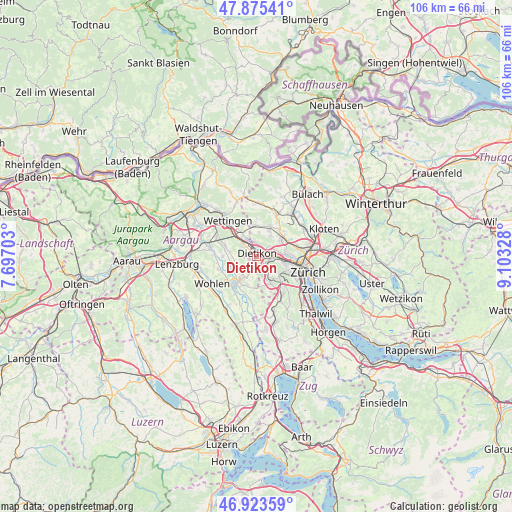
Dietikon GPS coordinates[2]
47° 24' 5.94" North, 8° 24' 0.54" East
| Map corner | latitude | longitude |
|---|---|---|
| Upper-left | 47.87541°, | 7.69703° |
| Center: | 47.40165°, | 8.40015° |
| Lower-right: | 46.92359°, | 9.10328° |
| Map W x H: | 105.8×105.8 km | = 65.7×65.7mi |
| max Lat: | 47.76737° ⇑25.9% North |
| Dietikon: | 47.40165° |
| min Lat: | ⇓74.1% South 45.83203° |
| min Long | Dietikon | max Long |
| 5.97153° | 8.40015° | 10.44624° |
| W 49.7%⇐ | ⇒50.3% E |
Elevation
Elevation of Dietikon is 397 m = 1302 ft, and this is 161.2 m = 529 ft below average elevation for this country.
| Max E: |
1845 m = 6053 ft | 89.3% |
| Avg. | 558.2 m = 1831 ft | |
| Dietikon | 397 m = 1302 ft | |
Min E: |
197 m = 646 ft | 10.7% |
See also: Switzerland elevation on elevation.city.
Geographical zone
Dietikon is located in North temperate zone (between Tropic of Cancer and the Arctic Circle). Distance of this North polar circle is 2130.6 km =1323.9 mi to North.| Distance of | km | miles | from Dietikon |
|---|---|---|---|
| North Pole | 4736.5 | 2943.1 | to North |
| Arctic Circle | 2130.6 | 1323.9 | to North |
| Tropic Cancer | 2664.7 | 1655.8 | to South |
| Equator | 5270.6 | 3275 | to South |


Nearby cities:
15 places around Dietikon: (largest is in red/bold)
• Dietikon / Almend
0.7 km =0.4 mi,  298°
298°
• Dietikon / Fondli
1.2 km =0.7 mi,  308°
308°
• Dietikon / Guggenbühl
0.6 km =0.4 mi,  106°
106°
• Dietikon / Hofacker
1.3 km =0.8 mi, 112°
• Dietikon / Kreuzacker
0.3 km =0.2 mi,  160°
160°
• Dietikon / Oberdorf
0.5 km =0.3 mi,  256°
256°
• Dietikon / Rütematt
0.9 km =0.6 mi,  175°
175°
• Dietikon / Schönenwerd
2 km =1.2 mi,  104°
104°
• Dietikon / Unterdorf
0.7 km =0.4 mi,  44°
44°
• Dietikon / Vorstadt
0.8 km =0.5 mi,  342°
342°
• Fahrweid (nördl. Teil)
1.8 km =1.1 mi, 38°
• Fahrweid (nördl. Teil) / Fahrweid
1.6 km =1 mi,  46°
46°
• Fahrweid (südl. Teil)
1.2 km =0.7 mi, 54°
• Urdorf / Bodenfeld
2.2 km =1.4 mi,  129°
129°
• Urdorf / Nieder-Urdorf
1.8 km =1.1 mi,  123°
123°
Sources, notices
• [Note1] Compared only with cities in Switzerland existing in our database
• [Src1] Map data: © OpenStreetMap contributors (CC-BY-SA)
• [Src2] Other city data from geonames.org with taken over terms of usage.
• [Src3] Geographical zone / Annual Mean Temperature by Robert A. Rohde @ Wikipedia
