Ecublens geodata
Ecublens (Vaud) is a seat of a third-order administrative division; located in Switzerland in Europe/Zurich (GMT+2) time zone. With population of 10,262 people, there are 142 cities with bigger population in this country. Compared to other cities in Switzerland, 84.5% of cities are located further ↑North; 94.6% of cities are located further →East and 81.2% of cities have higher elevation than Ecublens. Note1


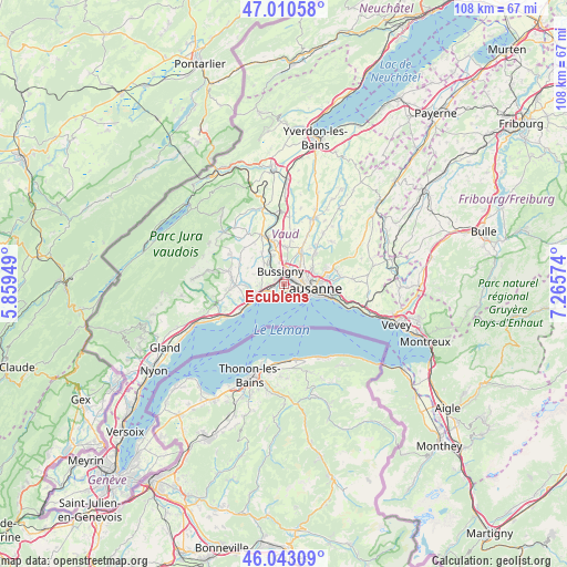
Ecublens GPS coordinates[2]
46° 31' 44.364" North, 6° 33' 45.396" East
| Map corner | latitude | longitude |
|---|---|---|
| Upper-left | 47.01058°, | 5.85949° |
| Center: | 46.52899°, | 6.56261° |
| Lower-right: | 46.04309°, | 7.26574° |
| Map W x H: | 107.6×107.6 km | = 66.9×66.9mi |
| max Lat: | 47.76737° ⇑84.5% North |
| Ecublens: | 46.52899° |
| min Lat: | ⇓15.5% South 45.83203° |
| min Long | Ecublens | max Long |
| 5.97153° | 6.56261° | 10.44624° |
| W 5.4%⇐ | ⇒94.6% E |
Elevation
Elevation of Ecublens is 419 m = 1375 ft, and this is 139.2 m = 457 ft below average elevation for this country.
| Max E: |
1845 m = 6053 ft | 81.2% |
| Avg. | 558.2 m = 1831 ft | |
| Ecublens | 419 m = 1375 ft | |
Min E: |
197 m = 646 ft | 18.8% |
See also: Switzerland elevation on elevation.city.
Geographical zone
Ecublens is located in North temperate zone (between Tropic of Cancer and the Arctic Circle). Distance of this North polar circle is 2227.6 km =1384.2 mi to North.| Distance of | km | miles | from Ecublens |
|---|---|---|---|
| North Pole | 4833.5 | 3003.4 | to North |
| Arctic Circle | 2227.6 | 1384.2 | to North |
| Tropic Cancer | 2567.6 | 1595.4 | to South |
| Equator | 5173.5 | 3214.7 | to South |


Nearby cities:
15 places around Ecublens: (largest is in red/bold)
• Blécherette
4.7 km =2.9 mi,  75°
75°
• Bussigny
2.5 km =1.6 mi,  348°
348°
• Chavannes
0.6 km =0.4 mi, 79°
• Cheseaux
7.2 km =4.5 mi,  27°
27°
• Colombier
7.5 km =4.7 mi,  294°
294°
• Crissier
2.1 km =1.3 mi, 28°
• Gollion
7.4 km =4.6 mi,  327°
327°
• Lausanne
5.6 km =3.5 mi,  105°
105°
• Le Mont-sur-Lausanne
6.2 km =3.9 mi,  58°
58°
• Morges
5.3 km =3.3 mi,  248°
248°
• Prilly
3.3 km =2.1 mi,  74°
74°
• Préverenges
3 km =1.9 mi, 247°
• Renens
2.3 km =1.4 mi, 58°
• Romanel-sur-Lausanne
5.1 km =3.2 mi,  40°
40°
• Vufflens-le-Château
6.9 km =4.3 mi,  267°
267°
Sources, notices
• [Note1] Compared only with cities in Switzerland existing in our database
• [Src1] Map data: © OpenStreetMap contributors (CC-BY-SA)
• [Src2] Other city data from geonames.org with taken over terms of usage.
• [Src3] Geographical zone / Annual Mean Temperature by Robert A. Rohde @ Wikipedia
