Bussigny geodata
Bussigny (Vaud) is a populated place; located in Switzerland in Europe/Zurich (GMT+2) time zone. With population of 7,408 people, there are 221 cities with bigger population in this country. Compared to other cities in Switzerland, 83.8% of cities are located further ↑North; 94.7% of cities are located further →East and 74.4% of cities have higher elevation than Bussigny. Note1


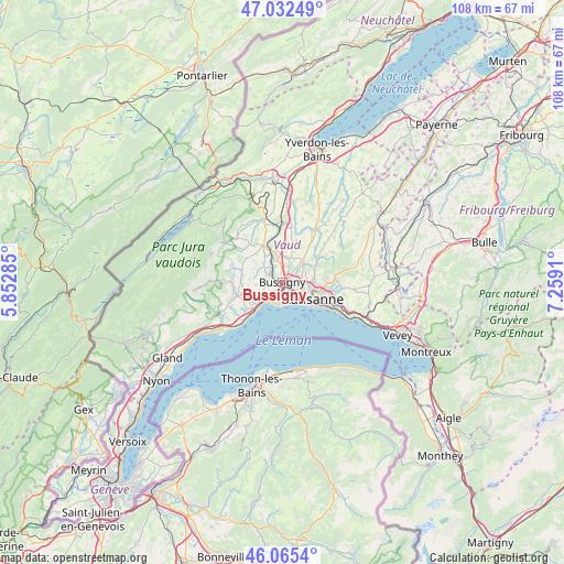
Bussigny GPS coordinates[2]
46° 33' 3.96" North, 6° 33' 21.492" East
| Map corner | latitude | longitude |
|---|---|---|
| Upper-left | 47.03249°, | 5.85285° |
| Center: | 46.5511°, | 6.55597° |
| Lower-right: | 46.0654°, | 7.2591° |
| Map W x H: | 107.5×107.5 km | = 66.8×66.8mi |
| max Lat: | 47.76737° ⇑83.8% North |
| Bussigny: | 46.5511° |
| min Lat: | ⇓16.2% South 45.83203° |
| min Long | Bussigny | max Long |
| 5.97153° | 6.55597° | 10.44624° |
| W 5.3%⇐ | ⇒94.7% E |
Elevation
Elevation of Bussigny is 432 m = 1417 ft, and this is 126.2 m = 414 ft below average elevation for this country.
| Max E: |
1845 m = 6053 ft | 74.4% |
| Avg. | 558.2 m = 1831 ft | |
| Bussigny | 432 m = 1417 ft | |
Min E: |
197 m = 646 ft | 25.6% |
See also: Switzerland elevation on elevation.city.
Geographical zone
Bussigny is located in North temperate zone (between Tropic of Cancer and the Arctic Circle). Distance of this North polar circle is 2225.2 km =1382.7 mi to North.| Distance of | km | miles | from Bussigny |
|---|---|---|---|
| North Pole | 4831.1 | 3001.9 | to North |
| Arctic Circle | 2225.2 | 1382.7 | to North |
| Tropic Cancer | 2570.1 | 1597 | to South |
| Equator | 5176 | 3216.2 | to South |


Nearby cities:
15 places around Bussigny: (largest is in red/bold)
• Blécherette
5.2 km =3.2 mi,  104°
104°
• Chavannes
2.6 km =1.6 mi,  154°
154°
• Cheseaux
5.5 km =3.4 mi,  44°
44°
• Colombier
6.4 km =4 mi,  275°
275°
• Crissier
1.6 km =1 mi,  111°
111°
• Ecublens
2.5 km =1.6 mi,  168°
168°
• Gollion
5.2 km =3.2 mi,  316°
316°
• Le Mont-sur-Lausanne
5.8 km =3.6 mi,  82°
82°
• Morges
6.2 km =3.9 mi,  224°
224°
• Penthalaz
7 km =4.3 mi,  340°
340°
• Prilly
4 km =2.5 mi, 112°
• Préverenges
4.3 km =2.7 mi,  211°
211°
• Renens
2.8 km =1.7 mi,  116°
116°
• Romanel-sur-Lausanne
4 km =2.5 mi,  69°
69°
• Vufflens-le-Château
7 km =4.3 mi,  246°
246°
Sources, notices
• [Note1] Compared only with cities in Switzerland existing in our database
• [Src1] Map data: © OpenStreetMap contributors (CC-BY-SA)
• [Src2] Other city data from geonames.org with taken over terms of usage.
• [Src3] Geographical zone / Annual Mean Temperature by Robert A. Rohde @ Wikipedia
