Pont-la-Ville geodata
Pont-la-Ville (Fribourg) is a seat of a third-order administrative division; located in Switzerland in Europe/Zurich (GMT+2) time zone. In our database, there are 1823 cities with bigger population. Compared to other cities in Switzerland, 78.5% of cities are located further ↑North; 84.6% of cities are located further →East and 88.7% of cities have lower elevation than Pont-la-Ville. Note1


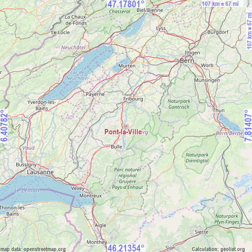
Pont-la-Ville GPS coordinates[2]
46° 41' 52.548" North, 7° 6' 39.384" East
| Map corner | latitude | longitude |
|---|---|---|
| Upper-left | 47.17801°, | 6.40782° |
| Center: | 46.69793°, | 7.11094° |
| Lower-right: | 46.21354°, | 7.81407° |
| Map W x H: | 107.2×107.2 km | = 66.6×66.6mi |
| max Lat: | 47.76737° ⇑78.5% North |
| Pont-la-Ville: | 46.69793° |
| min Lat: | ⇓21.5% South 45.83203° |
| min Long | Pont-la-Ville | max Long |
| 5.97153° | 7.11094° | 10.44624° |
| W 15.4%⇐ | ⇒84.6% E |
Elevation
Elevation of Pont-la-Ville is 788 m = 2585 ft, and this is 229.8 m = 754 ft above average elevation for this country.
| Max E: |
1845 m = 6053 ft | 11.3% |
| Pont-la-Ville | 788 m 2585 ft | |
| Avg. | 558.2 m = 1831 ft | |
Min E: |
197 m = 646 ft | 88.7% |
See also: Switzerland elevation on elevation.city.
Geographical zone
Pont-la-Ville is located in North temperate zone (between Tropic of Cancer and the Arctic Circle). Distance of this North polar circle is 2208.9 km =1372.5 mi to North.| Distance of | km | miles | from Pont-la-Ville |
|---|---|---|---|
| North Pole | 4814.7 | 2991.7 | to North |
| Arctic Circle | 2208.9 | 1372.5 | to North |
| Tropic Cancer | 2586.4 | 1607.1 | to South |
| Equator | 5192.3 | 3226.3 | to South |


Nearby cities:
15 places around Pont-la-Ville: (largest is in red/bold)
• Arconciel
5.6 km =3.5 mi,  8°
8°
• Autigny
8.2 km =5.1 mi,  301°
301°
• Bulle
9.8 km =6.1 mi,  204°
204°
• Charmey
9.6 km =6 mi,  154°
154°
• Ecuvillens
7 km =4.3 mi,  342°
342°
• Ependes
6.8 km =4.2 mi,  23°
23°
• Hauteville
3.1 km =1.9 mi,  180°
180°
• La Roche
2 km =1.2 mi,  95°
95°
• Marly
9.6 km =6 mi,  25°
25°
• Marsens
6.1 km =3.8 mi,  220°
220°
• Matran
9.8 km =6.1 mi,  354°
354°
• Praroman
7.8 km =4.8 mi,  40°
40°
• Riaz
7.2 km =4.5 mi,  211°
211°
• Sorens
5.5 km =3.4 mi,  234°
234°
• Treyvaux
3.9 km =2.4 mi, 31°
Sources, notices
• [Note1] Compared only with cities in Switzerland existing in our database
• [Src1] Map data: © OpenStreetMap contributors (CC-BY-SA)
• [Src2] Other city data from geonames.org with taken over terms of usage.
• [Src3] Geographical zone / Annual Mean Temperature by Robert A. Rohde @ Wikipedia
