Bocanda geodata
Bocanda (Lacs) is a seat of a third-order administrative division; located in Ivory Coast in Africa/Abidjan (GMT+0) time zone. With population of 13,079 people, there are 60 cities with bigger population in this country. Compared to other cities in Ivory Coast, 53.8% of cities are located further ↓South; 65.8% of cities are located further ←West and 75.2% of cities have higher elevation than Bocanda. Note1


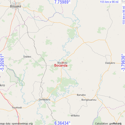
Bocanda GPS coordinates[2]
7° 3' 45.504" North, 4° 29' 58.128" West
| Map corner | latitude | longitude |
|---|---|---|
| Upper-left | 7.75989°, | -5.20261° |
| Center: | 7.06264°, | -4.49948° |
| Lower-right: | 6.36434°, | -3.79636° |
| Map W x H: | 155.2×155.2 km | = 96.4×96.4mi |
| max Lat: | 10.48115° ⇑46.2% North |
| Bocanda: | 7.06264° |
| min Lat: | ⇓53.8% South 4.42295° |
| min Long | Bocanda | max Long |
| -8.42592° | -4.49948° | -2.80003° |
| W 65.8%⇐ | ⇒34.2% E |
Elevation
Elevation of Bocanda is 115 m = 377 ft, and this is 109.3 m = 359 ft below average elevation for this country.
| Max E: |
556 m = 1824 ft | 75.2% |
| Avg. | 224.3 m = 736 ft | |
| Bocanda | 115 m = 377 ft | |
Min E: |
7 m = 23 ft | 24.8% |
See also: Ivory Coast elevation on elevation.city.
Geographical zone
Bocanda is located in North Torrid zone (between Equator and Tropic of Cancer). Distance of Equator is 785.3 km =488 mi to South.| Distance of | km | miles | from Bocanda |
|---|---|---|---|
| North Pole | 9221.8 | 5730.2 | to North |
| Arctic Circle | 6615.9 | 4110.9 | to North |
| Tropic Cancer | 1820.6 | 1131.3 | to North |
| Equator | 785.3 | 488 | to South |


Nearby cities:
15 places around Bocanda: (largest is in red/bold)
• Arrah
72.8 km =45.2 mi,  126°
126°
• Attiégouakro
75.1 km =46.7 mi,  244°
244°
• Bongouanou
56.1 km =34.9 mi,  144°
144°
• Bouaké
91.4 km =56.8 mi,  320°
320°
• Daoukro
59.2 km =36.8 mi,  90°
90°
• Didiévi
44.6 km =27.7 mi,  279°
279°
• Dimbokro
51.5 km =32 mi,  206°
206°
• Djékanou
93.6 km =58.2 mi,  226°
226°
• Kouassi-Kouassikro
36.7 km =22.8 mi,  327°
327°
• M’Bahiakro
47.3 km =29.4 mi,  21°
21°
• M’Batto
67.5 km =41.9 mi,  166°
166°
• Prikro
85.5 km =53.1 mi,  40°
40°
• Tiébissou
80.7 km =50.1 mi, 277°
• Toumodi
80.1 km =49.8 mi, 225°
• Yamoussoukro
89.9 km =55.9 mi,  252°
252°
Sources, notices
• [Note1] Compared only with cities in Ivory Coast existing in our database
• [Src1] Map data: © OpenStreetMap contributors (CC-BY-SA)
• [Src2] Other city data from geonames.org with taken over terms of usage.
• [Src3] Geographical zone / Annual Mean Temperature by Robert A. Rohde @ Wikipedia
