Arrah geodata
Arrah (Lacs) is a seat of a third-order administrative division; located in Ivory Coast in Africa/Abidjan (GMT+0) time zone. With population of 37,432 people, there are 37 cities with bigger population in this country. Compared to other cities in Ivory Coast, 55.6% of cities are located further ↑North; 77.8% of cities are located further ←West and 69.2% of cities have higher elevation than Arrah. Note1


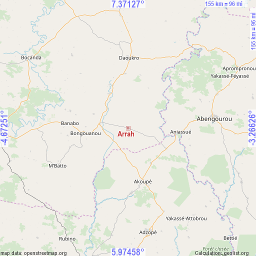
Arrah GPS coordinates[2]
6° 40' 24.312" North, 3° 58' 9.768" West
| Map corner | latitude | longitude |
|---|---|---|
| Upper-left | 7.37127°, | -4.67251° |
| Center: | 6.67342°, | -3.96938° |
| Lower-right: | 5.97458°, | -3.26626° |
| Map W x H: | 155.3×155.3 km | = 96.5×96.5mi |
| max Lat: | 10.48115° ⇑55.6% North |
| Arrah: | 6.67342° |
| min Lat: | ⇓44.4% South 4.42295° |
| min Long | Arrah | max Long |
| -8.42592° | -3.96938° | -2.80003° |
| W 77.8%⇐ | ⇒22.2% E |
Elevation
Elevation of Arrah is 143 m = 469 ft, and this is 81.3 m = 267 ft below average elevation for this country.
| Max E: |
556 m = 1824 ft | 69.2% |
| Avg. | 224.3 m = 736 ft | |
| Arrah | 143 m = 469 ft | |
Min E: |
7 m = 23 ft | 30.8% |
See also: Ivory Coast elevation on elevation.city.
Geographical zone
Arrah is located in North Torrid zone (between Equator and Tropic of Cancer). Distance of Equator is 742 km =461.1 mi to South.| Distance of | km | miles | from Arrah |
|---|---|---|---|
| North Pole | 9265 | 5757 | to North |
| Arctic Circle | 6659.2 | 4137.8 | to North |
| Tropic Cancer | 1863.9 | 1158.2 | to North |
| Equator | 742 | 461.1 | to South |


Nearby cities:
15 places around Arrah: (largest is in red/bold)
• Abengourou
52.6 km =32.7 mi,  83°
83°
• Adzopé
64.1 km =39.8 mi,  169°
169°
• Affery
39.3 km =24.4 mi,  177°
177°
• Agboville
87.2 km =54.2 mi,  198°
198°
• Agnibilékrou
98.6 km =61.3 mi,  58°
58°
• Agou
76.8 km =47.7 mi, 177°
• Akoupé
33.4 km =20.8 mi,  164°
164°
• Bocanda
72.8 km =45.2 mi,  306°
306°
• Bongouanou
26 km =16.2 mi,  264°
264°
• Béttié
90.9 km =56.5 mi,  136°
136°
• Daoukro
42.9 km =26.7 mi,  0°
0°
• Dimbokro
81.3 km =50.5 mi,  267°
267°
• M’Bahiakro
96.3 km =59.8 mi,  334°
334°
• M’Batto
48.4 km =30.1 mi,  242°
242°
• Yakassé-Attobrou
65 km =40.4 mi,  147°
147°
Sources, notices
• [Note1] Compared only with cities in Ivory Coast existing in our database
• [Src1] Map data: © OpenStreetMap contributors (CC-BY-SA)
• [Src2] Other city data from geonames.org with taken over terms of usage.
• [Src3] Geographical zone / Annual Mean Temperature by Robert A. Rohde @ Wikipedia
