Bouaké geodata
Bouaké (Vallée du Bandama) is a seat of a first-order administrative division; located in Ivory Coast in Africa/Abidjan (GMT+0) time zone. With population of 567,481 people, there are 2 cities with bigger population in this country. Compared to other cities in Ivory Coast, 68.4% of cities are located further ↓South; 58.1% of cities are located further ←West and 78.6% of cities have lower elevation than Bouaké. Note1


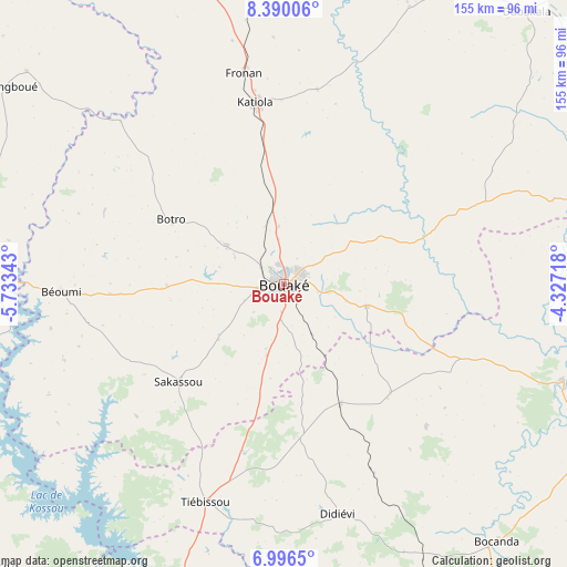
Bouaké GPS coordinates[2]
7° 41' 37.86" North, 5° 1' 49.116" West
| Map corner | latitude | longitude |
|---|---|---|
| Upper-left | 8.39006°, | -5.73343° |
| Center: | 7.69385°, | -5.03031° |
| Lower-right: | 6.9965°, | -4.32718° |
| Map W x H: | 154.9×155 km | = 96.3×96.3mi |
| max Lat: | 10.48115° ⇑31.6% North |
| Bouaké: | 7.69385° |
| min Lat: | ⇓68.4% South 4.42295° |
| min Long | Bouaké | max Long |
| -8.42592° | -5.03031° | -2.80003° |
| W 58.1%⇐ | ⇒41.9% E |
Elevation
Elevation of Bouaké is 339 m = 1112 ft, and this is 114.7 m = 376 ft above average elevation for this country.
| Max E: |
556 m = 1824 ft | 21.4% |
| Bouaké | 339 m 1112 ft | |
| Avg. | 224.3 m = 736 ft | |
Min E: |
7 m = 23 ft | 78.6% |
See also: Bouaké elevation on elevation.city.
Geographical zone
Bouaké is located in North Torrid zone (between Equator and Tropic of Cancer). Distance of Equator is 855.5 km =531.6 mi to South.| Distance of | km | miles | from Bouaké |
|---|---|---|---|
| North Pole | 9151.6 | 5686.5 | to North |
| Arctic Circle | 6545.7 | 4067.3 | to North |
| Tropic Cancer | 1750.4 | 1087.6 | to North |
| Equator | 855.5 | 531.6 | to South |


Nearby cities:
15 places around Bouaké: (largest is in red/bold)
• Attiégouakro
102.7 km =63.8 mi,  185°
185°
• Bocanda
91.4 km =56.8 mi,  140°
140°
• Botro
35.6 km =22.1 mi,  299°
299°
• Bouaflé
111 km =69 mi,  225°
225°
• Béoumi
60.7 km =37.7 mi,  267°
267°
• Dabakala
99.6 km =61.9 mi,  41°
41°
• Didiévi
64.5 km =40.1 mi,  166°
166°
• Katiola
49.9 km =31 mi,  351°
351°
• Kouassi-Kouassikro
55.2 km =34.3 mi, 135°
• Kounahiri
89.3 km =55.5 mi,  276°
276°
• M’Bahiakro
80.5 km =50 mi,  109°
109°
• Niakaramandougou
110.9 km =68.9 mi, 345°
• Sakassou
39.3 km =24.4 mi, 227°
• Tiébissou
63.4 km =39.4 mi,  199°
199°
• Yamoussoukro
100.8 km =62.6 mi, 195°
Sources, notices
• [Note1] Compared only with cities in Ivory Coast existing in our database
• [Src1] Map data: © OpenStreetMap contributors (CC-BY-SA)
• [Src2] Other city data from geonames.org with taken over terms of usage.
• [Src3] Geographical zone / Annual Mean Temperature by Robert A. Rohde @ Wikipedia
