Zibu geodata
Zibu (Jiangxi) is a seat of a fourth-order administrative division; located in China in Asia/Shanghai (GMT+8) time zone. In our database, there are 1268 cities with bigger population. Compared to other cities in China, 66.8% of cities are located further ↑North; 65.3% of cities are located further ←West and 82.9% of cities have higher elevation than Zibu. Note1


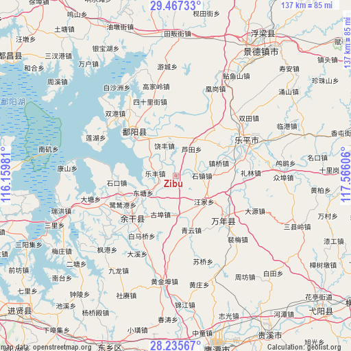
Zibu GPS coordinates[2]
28° 51' 11.952" North, 116° 51' 46.548" East
| Map corner | latitude | longitude |
|---|---|---|
| Upper-left | 29.46733°, | 116.15981° |
| Center: | 28.85332°, | 116.86293° |
| Lower-right: | 28.23567°, | 117.56606° |
| Map W x H: | 136.9×136.9 km | = 85.1×85.1mi |
| max Lat: | 53.31946° ⇑66.8% North |
| Zibu: | 28.85332° |
| min Lat: | ⇓33.2% South 18.22056° |
| min Long | Zibu | max Long |
| 75.07348° | 116.86293° | 134.28917° |
| W 65.3%⇐ | ⇒34.7% E |
Elevation
Elevation of Zibu is 20 m = 66 ft, and this is 464.8 m = 1525 ft below average elevation for this country.
| Max E: |
5622 m = 18445 ft | 82.9% |
| Avg. | 484.8 m = 1591 ft | |
| Zibu | 20 m = 66 ft | |
Min E: |
-3 m = -10 ft | 17.1% |
See also: China elevation on elevation.city.
Geographical zone
Zibu is located in North temperate zone (between Tropic of Cancer and the Arctic Circle). Distance of this Northern Tropic circle is 602.3 km =374.3 mi to South.| Distance of | km | miles | from Zibu |
|---|---|---|---|
| North Pole | 6798.9 | 4224.6 | to North |
| Arctic Circle | 4193 | 2605.4 | to North |
| Tropic Cancer | 602.3 | 374.3 | to South |
| Equator | 3208.2 | 1993.5 | to South |


Nearby cities:
15 places around Zibu: (largest is in red/bold)
• Dahuang
10.4 km =6.5 mi,  138°
138°
• Gubu
16.3 km =10.1 mi,  201°
201°
• Hualingang
23.3 km =14.5 mi,  225°
225°
• Huyunxiang
8.4 km =5.2 mi,  217°
217°
• Lefengzhen
8.3 km =5.2 mi,  277°
277°
• Lutianxiang
12.1 km =7.5 mi,  30°
30°
• Qibu
14.7 km =9.1 mi,  179°
179°
• Qingyun
22.1 km =13.7 mi,  164°
164°
• Raobu
8.7 km =5.4 mi,  71°
71°
• Raofeng
12.2 km =7.6 mi,  339°
339°
• Sanmiaoqian
16 km =9.9 mi,  324°
324°
• Shizhen
10.1 km =6.3 mi,  89°
89°
• Tongshanxiang
6.7 km =4.2 mi,  257°
257°
• Wangjia
17.7 km =11 mi, 155°
• Zhenqiao
17.5 km =10.9 mi, 73°
Sources, notices
• [Note1] Compared only with cities in China existing in our database
• [Src1] Map data: © OpenStreetMap contributors (CC-BY-SA)
• [Src2] Other city data from geonames.org with taken over terms of usage.
• [Src3] Geographical zone / Annual Mean Temperature by Robert A. Rohde @ Wikipedia
