Tongshanxiang geodata
Tongshanxiang (Jiangxi) is a seat of a fourth-order administrative division; located in China in Asia/Shanghai (GMT+8) time zone. In our database, there are 1268 cities with bigger population. Compared to other cities in China, 66.9% of cities are located further ↑North; 64.9% of cities are located further ←West and 77.7% of cities have higher elevation than Tongshanxiang. Note1


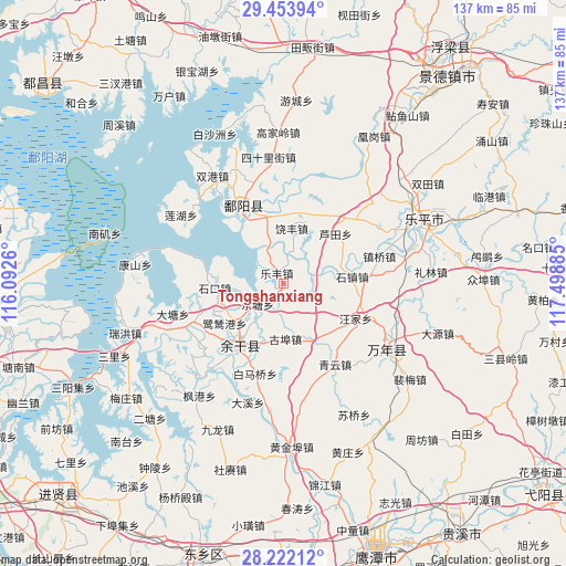
Tongshanxiang GPS coordinates[2]
28° 50' 23.46" North, 116° 47' 44.592" East
| Map corner | latitude | longitude |
|---|---|---|
| Upper-left | 29.45394°, | 116.0926° |
| Center: | 28.83985°, | 116.79572° |
| Lower-right: | 28.22212°, | 117.49885° |
| Map W x H: | 137×137 km | = 85.1×85.1mi |
| max Lat: | 53.31946° ⇑66.9% North |
| Tongshanxiang: | 28.83985° |
| min Lat: | ⇓33.1% South 18.22056° |
| min Long | Tongshanxiang | max Long |
| 75.07348° | 116.79572° | 134.28917° |
| W 64.9%⇐ | ⇒35.1% E |
Elevation
Elevation of Tongshanxiang is 31 m = 102 ft, and this is 453.8 m = 1489 ft below average elevation for this country.
| Max E: |
5622 m = 18445 ft | 77.7% |
| Avg. | 484.8 m = 1591 ft | |
| Tongshanxiang | 31 m = 102 ft | |
Min E: |
-3 m = -10 ft | 22.3% |
See also: China elevation on elevation.city.
Geographical zone
Tongshanxiang is located in North temperate zone (between Tropic of Cancer and the Arctic Circle). Distance of this Northern Tropic circle is 600.8 km =373.3 mi to South.| Distance of | km | miles | from Tongshanxiang |
|---|---|---|---|
| North Pole | 6800.4 | 4225.6 | to North |
| Arctic Circle | 4194.5 | 2606.3 | to North |
| Tropic Cancer | 600.8 | 373.3 | to South |
| Equator | 3206.7 | 1992.6 | to South |


Nearby cities:
15 places around Tongshanxiang: (largest is in red/bold)
• Dahuang
14.8 km =9.2 mi,  115°
115°
• Gubu
13.6 km =8.5 mi,  177°
177°
• Hualingang
17.9 km =11.1 mi,  213°
213°
• Huyunxiang
5.4 km =3.4 mi,  164°
164°
• Lefengzhen
3.1 km =1.9 mi,  327°
327°
• Lusigang
17.1 km =10.6 mi,  236°
236°
• Lutianxiang
17.4 km =10.8 mi,  46°
46°
• Qibu
14.7 km =9.1 mi,  153°
153°
• Raobu
15.4 km =9.6 mi,  73°
73°
• Raofeng
13.2 km =8.2 mi,  10°
10°
• Sanmiaoqian
14.8 km =9.2 mi,  349°
349°
• Shikou
16.7 km =10.4 mi,  265°
265°
• Shizhen
16.7 km =10.4 mi,  84°
84°
• Yugan
19.4 km =12.1 mi, 214°
• Zibu
6.7 km =4.2 mi, 77°
Sources, notices
• [Note1] Compared only with cities in China existing in our database
• [Src1] Map data: © OpenStreetMap contributors (CC-BY-SA)
• [Src2] Other city data from geonames.org with taken over terms of usage.
• [Src3] Geographical zone / Annual Mean Temperature by Robert A. Rohde @ Wikipedia
