Runing geodata
Runing (Henan) is a seat of a third-order administrative division; located in China in Asia/Shanghai (GMT+8) time zone. With population of 60,202 people, there are 729 cities with bigger population in this country. Compared to other cities in China, 66% of cities are located further ↓South; 50.7% of cities are located further ←West and 68.9% of cities have higher elevation than Runing. Note1


Runing GPS coordinates[2]
33° 0' 3.996" North, 114° 21' 15.012" East
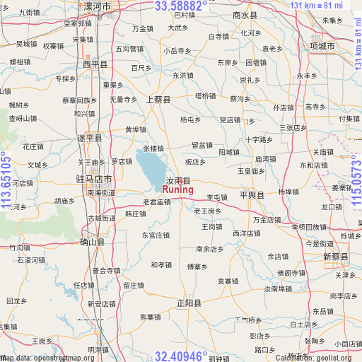
| Map corner | latitude | longitude |
|---|---|---|
| Upper-left | 33.58882°, | 113.65105° |
| Center: | 33.00111°, | 114.35417° |
| Lower-right: | 32.40946°, | 115.0573° |
| Map W x H: | 131.1×131.1 km | = 81.5×81.5mi |
| max Lat: | 53.31946° ⇑34% North |
| Runing: | 33.00111° |
| min Lat: | ⇓66% South 18.22056° |
| min Long | Runing | max Long |
| 75.07348° | 114.35417° | 134.28917° |
| W 50.7%⇐ | ⇒49.3% E |
Elevation
Elevation of Runing is 56 m = 184 ft, and this is 428.8 m = 1407 ft below average elevation for this country.
| Max E: |
5622 m = 18445 ft | 68.9% |
| Avg. | 484.8 m = 1591 ft | |
| Runing | 56 m = 184 ft | |
Min E: |
-3 m = -10 ft | 31.1% |
See also: Runing elevation on elevation.city.
Geographical zone
Runing is located in North temperate zone (between Tropic of Cancer and the Arctic Circle). Distance of this Northern Tropic circle is 1063.5 km =660.8 mi to South.| Distance of | km | miles | from Runing |
|---|---|---|---|
| North Pole | 6337.7 | 3938.1 | to North |
| Arctic Circle | 3731.8 | 2318.8 | to North |
| Tropic Cancer | 1063.5 | 660.8 | to South |
| Equator | 3669.4 | 2280.1 | to South |


Nearby cities:
15 places around Runing: (largest is in red/bold)
• Baicheng
53.2 km =33.1 mi,  323°
323°
• Chongyang
30.5 km =19 mi,  340°
340°
• Guhuai
25.7 km =16 mi,  100°
100°
• Hexing
42.7 km =26.5 mi,  305°
305°
• Liuge
35.7 km =22.2 mi,  266°
266°
• Panlong
38.3 km =23.8 mi,  234°
234°
• Quyang
37.5 km =23.3 mi,  295°
295°
• Shenzhai
52.3 km =32.5 mi, 299°
• Wencheng
52.2 km =32.4 mi,  276°
276°
• Yangfeng
49 km =30.4 mi,  287°
287°
• Yushan
54.8 km =34.1 mi, 293°
• Zhenyang
44.3 km =27.5 mi,  176°
176°
• Zhuantan
56.1 km =34.9 mi, 311°
• Zhumadian
30.4 km =18.9 mi, 265°
• Zhushi
43.9 km =27.3 mi, 278°
Sources, notices
• [Note1] Compared only with cities in China existing in our database
• [Src1] Map data: © OpenStreetMap contributors (CC-BY-SA)
• [Src2] Other city data from geonames.org with taken over terms of usage.
• [Src3] Geographical zone / Annual Mean Temperature by Robert A. Rohde @ Wikipedia
