Zhitang geodata
Zhitang (Jiangsu) is a seat of a fourth-order administrative division; located in China in Asia/Shanghai (GMT+8) time zone. In our database, there are 1268 cities with bigger population. Compared to other cities in China, 59% of cities are located further ↓South; 87.6% of cities are located further ←West and 98.3% of cities have higher elevation than Zhitang. Note1


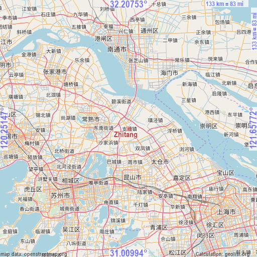
Zhitang GPS coordinates[2]
31° 36' 38.376" North, 120° 57' 16.524" East
| Map corner | latitude | longitude |
|---|---|---|
| Upper-left | 32.20753°, | 120.25147° |
| Center: | 31.61066°, | 120.95459° |
| Lower-right: | 31.00994°, | 121.65772° |
| Map W x H: | 133.2×133.2 km | = 82.8×82.8mi |
| max Lat: | 53.31946° ⇑41% North |
| Zhitang: | 31.61066° |
| min Lat: | ⇓59% South 18.22056° |
| min Long | Zhitang | max Long |
| 75.07348° | 120.95459° | 134.28917° |
| W 87.6%⇐ | ⇒12.4% E |
Elevation
Elevation of Zhitang is 4 m = 13 ft, and this is 480.8 m = 1577 ft below average elevation for this country.
| Max E: |
5622 m = 18445 ft | 98.3% |
| Avg. | 484.8 m = 1591 ft | |
| Zhitang | 4 m = 13 ft | |
Min E: |
-3 m = -10 ft | 1.7% |
See also: China elevation on elevation.city.
Geographical zone
Zhitang is located in North temperate zone (between Tropic of Cancer and the Arctic Circle). Distance of this Northern Tropic circle is 908.9 km =564.8 mi to South.| Distance of | km | miles | from Zhitang |
|---|---|---|---|
| North Pole | 6492.3 | 4034.1 | to North |
| Arctic Circle | 3886.4 | 2414.9 | to North |
| Tropic Cancer | 908.9 | 564.8 | to South |
| Equator | 3514.8 | 2184 | to South |


Nearby cities:
15 places around Zhitang: (largest is in red/bold)
• Bacheng
18.7 km =11.6 mi,  204°
204°
• Changshu City
20.5 km =12.7 mi,  281°
281°
• Chengxiang
22.4 km =13.9 mi,  143°
143°
• Dongbang
5 km =3.1 mi,  327°
327°
• Fuqiao
23.9 km =14.9 mi,  91°
91°
• Guli
11.6 km =7.2 mi, 281°
• Haiyu
21.4 km =13.3 mi,  317°
317°
• Huangjing
15 km =9.3 mi,  72°
72°
• Meili
13.8 km =8.6 mi, 322°
• Shajiabang
12.2 km =7.6 mi,  235°
235°
• Shaxi
10.9 km =6.8 mi,  116°
116°
• Shuangfeng
12.4 km =7.7 mi,  147°
147°
• Xingang
13.1 km =8.1 mi,  345°
345°
• Yushan
16.3 km =10.1 mi,  297°
297°
• Zhoushi
16.5 km =10.3 mi,  168°
168°
Sources, notices
• [Note1] Compared only with cities in China existing in our database
• [Src1] Map data: © OpenStreetMap contributors (CC-BY-SA)
• [Src2] Other city data from geonames.org with taken over terms of usage.
• [Src3] Geographical zone / Annual Mean Temperature by Robert A. Rohde @ Wikipedia
