Changshu City geodata
Changshu City (Jiangsu) is a populated place; located in China in Asia/Shanghai (GMT+8) time zone. With population of 1,047,700 people, there are 61 cities with bigger population in this country. Compared to other cities in China, 59.2% of cities are located further ↓South; 86.5% of cities are located further ←West and 91.2% of cities have higher elevation than Changshu City. Note1


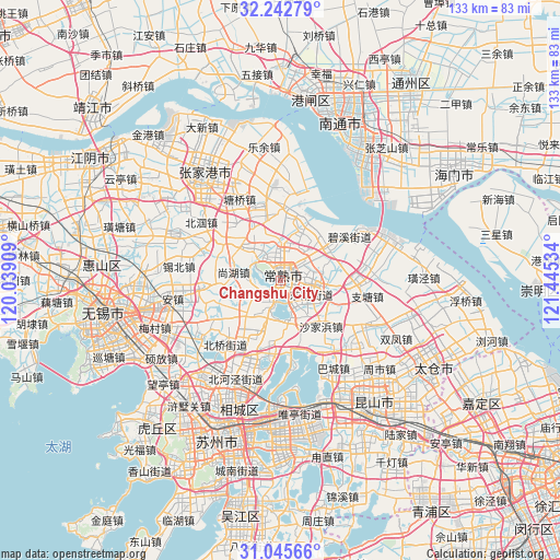
Changshu City GPS coordinates[2]
31° 38' 46.14" North, 120° 44' 31.956" East
| Map corner | latitude | longitude |
|---|---|---|
| Upper-left | 32.24279°, | 120.03909° |
| Center: | 31.64615°, | 120.74221° |
| Lower-right: | 31.04566°, | 121.44534° |
| Map W x H: | 133.1×133.1 km | = 82.7×82.7mi |
| max Lat: | 53.31946° ⇑40.8% North |
| Changshu City: | 31.64615° |
| min Lat: | ⇓59.2% South 18.22056° |
| min Long | Changshu City | max Long |
| 75.07348° | 120.74221° | 134.28917° |
| W 86.5%⇐ | ⇒13.5% E |
Elevation
Elevation of Changshu City is 9 m = 30 ft, and this is 475.8 m = 1561 ft below average elevation for this country.
| Max E: |
5622 m = 18445 ft | 91.2% |
| Avg. | 484.8 m = 1591 ft | |
| Changshu City | 9 m = 30 ft | |
Min E: |
-3 m = -10 ft | 8.8% |
See also: Changshu City elevation on elevation.city.
Geographical zone
Changshu City is located in North temperate zone (between Tropic of Cancer and the Arctic Circle). Distance of this Northern Tropic circle is 912.8 km =567.2 mi to South.| Distance of | km | miles | from Changshu City |
|---|---|---|---|
| North Pole | 6488.3 | 4031.6 | to North |
| Arctic Circle | 3882.5 | 2412.5 | to North |
| Tropic Cancer | 912.8 | 567.2 | to South |
| Equator | 3518.7 | 2186.4 | to South |


Nearby cities:
15 places around Changshu City: (largest is in red/bold)
• Beiqiao
20.7 km =12.9 mi,  222°
222°
• Dongbang
17.4 km =10.8 mi,  89°
89°
• Fenghuang
19.6 km =12.2 mi,  325°
325°
• Guli
8.9 km =5.5 mi,  100°
100°
• Gushan
20.7 km =12.9 mi,  297°
297°
• Haiyu
13 km =8.1 mi,  25°
25°
• Meili
13.6 km =8.5 mi,  58°
58°
• Shajiabang
14.8 km =9.2 mi,  137°
137°
• Shanghu
11.1 km =6.9 mi,  283°
283°
• Xingang
19 km =11.8 mi, 62°
• Xinzhuang
13.1 km =8.1 mi,  202°
202°
• Yangdenghu
17.1 km =10.6 mi,  185°
185°
• Yangjian
17.9 km =11.1 mi,  263°
263°
• Yushan
6.6 km =4.1 mi, 58°
• Zhitang
20.5 km =12.7 mi, 101°
Sources, notices
• [Note1] Compared only with cities in China existing in our database
• [Src1] Map data: © OpenStreetMap contributors (CC-BY-SA)
• [Src2] Other city data from geonames.org with taken over terms of usage.
• [Src3] Geographical zone / Annual Mean Temperature by Robert A. Rohde @ Wikipedia
