Chengxiang geodata
Chengxiang (Jiangsu) is a seat of a third-order administrative division; located in China in Asia/Shanghai (GMT+8) time zone. In our database, there are 1268 cities with bigger population. Compared to other cities in China, 58.1% of cities are located further ↓South; 88.1% of cities are located further ←West and 98.3% of cities have higher elevation than Chengxiang. Note1


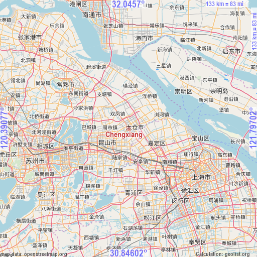
Chengxiang GPS coordinates[2]
31° 26' 52.008" North, 121° 5' 38.004" East
| Map corner | latitude | longitude |
|---|---|---|
| Upper-left | 32.0457°, | 120.39077° |
| Center: | 31.44778°, | 121.09389° |
| Lower-right: | 30.84602°, | 121.79702° |
| Map W x H: | 133.4×133.4 km | = 82.9×82.9mi |
| max Lat: | 53.31946° ⇑41.9% North |
| Chengxiang: | 31.44778° |
| min Lat: | ⇓58.1% South 18.22056° |
| min Long | Chengxiang | max Long |
| 75.07348° | 121.09389° | 134.28917° |
| W 88.1%⇐ | ⇒11.9% E |
Elevation
Elevation of Chengxiang is 4 m = 13 ft, and this is 480.8 m = 1577 ft below average elevation for this country.
| Max E: |
5622 m = 18445 ft | 98.3% |
| Avg. | 484.8 m = 1591 ft | |
| Chengxiang | 4 m = 13 ft | |
Min E: |
-3 m = -10 ft | 1.7% |
See also: China elevation on elevation.city.
Geographical zone
Chengxiang is located in North temperate zone (between Tropic of Cancer and the Arctic Circle). Distance of this Northern Tropic circle is 890.7 km =553.5 mi to South.| Distance of | km | miles | from Chengxiang |
|---|---|---|---|
| North Pole | 6510.4 | 4045.4 | to North |
| Arctic Circle | 3904.5 | 2426.1 | to North |
| Tropic Cancer | 890.7 | 553.5 | to South |
| Equator | 3496.7 | 2172.7 | to South |


Nearby cities:
15 places around Chengxiang: (largest is in red/bold)
• Anting
17.6 km =10.9 mi,  159°
159°
• Fuqiao
20.4 km =12.7 mi,  31°
31°
• Huaqiao
16.3 km =10.1 mi,  183°
183°
• Huating
13.7 km =8.5 mi,  83°
83°
• Jiadingzhen
15.9 km =9.9 mi,  115°
115°
• Kunshan
15.4 km =9.6 mi,  239°
239°
• Liuhe
17.4 km =10.8 mi,  67°
67°
• Ludu
9 km =5.6 mi, 72°
• Lujia
15.4 km =9.6 mi,  198°
198°
• Shaxi
13.6 km =8.5 mi,  345°
345°
• Shuangfeng
10 km =6.2 mi,  319°
319°
• Waigang
11.9 km =7.4 mi,  142°
142°
• Xinchenglu
17.3 km =10.7 mi,  112°
112°
• Xuhang
17.2 km =10.7 mi,  103°
103°
• Zhoushi
10 km =6.2 mi,  281°
281°
Sources, notices
• [Note1] Compared only with cities in China existing in our database
• [Src1] Map data: © OpenStreetMap contributors (CC-BY-SA)
• [Src2] Other city data from geonames.org with taken over terms of usage.
• [Src3] Geographical zone / Annual Mean Temperature by Robert A. Rohde @ Wikipedia
