Zhangjiashan geodata
Zhangjiashan (Jiangxi) is a seat of a fourth-order administrative division; located in China in Asia/Shanghai (GMT+8) time zone. In our database, there are 1268 cities with bigger population. Compared to other cities in China, 73.4% of cities are located further ↑North; 56.9% of cities are located further ←West and 78.3% of cities have higher elevation than Zhangjiashan. Note1


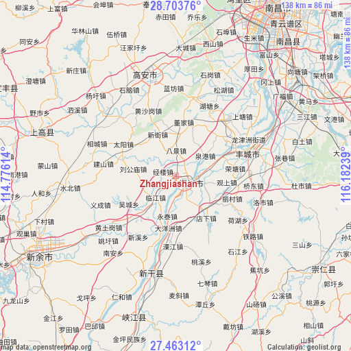
Zhangjiashan GPS coordinates[2]
28° 5' 6.828" North, 115° 28' 45.336" East
| Map corner | latitude | longitude |
|---|---|---|
| Upper-left | 28.70376°, | 114.77614° |
| Center: | 28.08523°, | 115.47926° |
| Lower-right: | 27.46312°, | 116.18239° |
| Map W x H: | 137.9×137.9 km | = 85.7×85.7mi |
| max Lat: | 53.31946° ⇑73.4% North |
| Zhangjiashan: | 28.08523° |
| min Lat: | ⇓26.6% South 18.22056° |
| min Long | Zhangjiashan | max Long |
| 75.07348° | 115.47926° | 134.28917° |
| W 56.9%⇐ | ⇒43.1% E |
Elevation
Elevation of Zhangjiashan is 30 m = 98 ft, and this is 454.8 m = 1492 ft below average elevation for this country.
| Max E: |
5622 m = 18445 ft | 78.3% |
| Avg. | 484.8 m = 1591 ft | |
| Zhangjiashan | 30 m = 98 ft | |
Min E: |
-3 m = -10 ft | 21.7% |
See also: China elevation on elevation.city.
Geographical zone
Zhangjiashan is located in North temperate zone (between Tropic of Cancer and the Arctic Circle). Distance of this Northern Tropic circle is 516.9 km =321.2 mi to South.| Distance of | km | miles | from Zhangjiashan |
|---|---|---|---|
| North Pole | 6884.3 | 4277.7 | to North |
| Arctic Circle | 4278.4 | 2658.5 | to North |
| Tropic Cancer | 516.9 | 321.2 | to South |
| Equator | 3122.8 | 1940.4 | to South |


Nearby cities:
15 places around Zhangjiashan: (largest is in red/bold)
• Bajing
10.2 km =6.3 mi,  2°
2°
• Daqiao
10.5 km =6.5 mi,  108°
108°
• Dayangzhou
20.7 km =12.9 mi,  188°
188°
• Dianxia
20.4 km =12.7 mi,  144°
144°
• Ducheng
16.5 km =10.3 mi, 4°
• Jinglou
5.5 km =3.4 mi,  287°
287°
• Liugongmiao
17.3 km =10.7 mi,  279°
279°
• Quangang
13.9 km =8.6 mi,  55°
55°
• Sanhu
18.6 km =11.6 mi,  195°
195°
• Tuochuan
19.3 km =12 mi,  66°
66°
• Xinjie
17.8 km =11.1 mi,  337°
337°
• Xinjiezhen
17.8 km =11.1 mi, 337°
• Yanghuxiang
7.1 km =4.4 mi,  168°
168°
• Yongtai
16.2 km =10.1 mi, 192°
• Zhoushang
11.3 km =7 mi,  217°
217°
Sources, notices
• [Note1] Compared only with cities in China existing in our database
• [Src1] Map data: © OpenStreetMap contributors (CC-BY-SA)
• [Src2] Other city data from geonames.org with taken over terms of usage.
• [Src3] Geographical zone / Annual Mean Temperature by Robert A. Rohde @ Wikipedia
