Zhangjiahe geodata
Zhangjiahe (Shaanxi) is a seat of a fourth-order administrative division; located in China in Asia/Shanghai (GMT+8) time zone. In our database, there are 1268 cities with bigger population. Compared to other cities in China, 67.8% of cities are located further ↓South; 84.9% of cities are located further →East and 88% of cities have lower elevation than Zhangjiahe. Note1


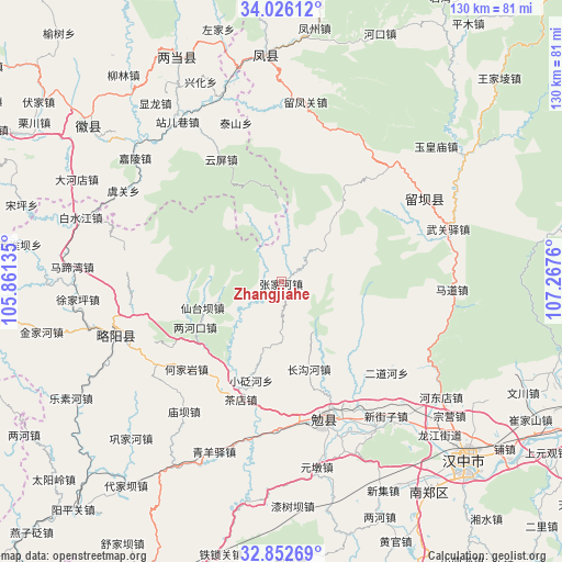
Zhangjiahe GPS coordinates[2]
33° 26' 29.004" North, 106° 33' 52.092" East
| Map corner | latitude | longitude |
|---|---|---|
| Upper-left | 34.02612°, | 105.86135° |
| Center: | 33.44139°, | 106.56447° |
| Lower-right: | 32.85269°, | 107.2676° |
| Map W x H: | 130.5×130.5 km | = 81.1×81.1mi |
| max Lat: | 53.31946° ⇑32.2% North |
| Zhangjiahe: | 33.44139° |
| min Lat: | ⇓67.8% South 18.22056° |
| min Long | Zhangjiahe | max Long |
| 75.07348° | 106.56447° | 134.28917° |
| W 15.1%⇐ | ⇒84.9% E |
Elevation
Elevation of Zhangjiahe is 1182 m = 3878 ft, and this is 697.2 m = 2287 ft above average elevation for this country.
| Max E: |
5622 m = 18445 ft | 12% |
| Zhangjiahe | 1182 m 3878 ft | |
| Avg. | 484.8 m = 1591 ft | |
Min E: |
-3 m = -10 ft | 88% |
See also: China elevation on elevation.city.
Geographical zone
Zhangjiahe is located in North temperate zone (between Tropic of Cancer and the Arctic Circle). Distance of this Northern Tropic circle is 1112.4 km =691.2 mi to South.| Distance of | km | miles | from Zhangjiahe |
|---|---|---|---|
| North Pole | 6288.7 | 3907.6 | to North |
| Arctic Circle | 3682.8 | 2288.4 | to North |
| Tropic Cancer | 1112.4 | 691.2 | to South |
| Equator | 3718.3 | 2310.4 | to South |


Nearby cities:
15 places around Zhangjiahe: (largest is in red/bold)
• Chadian
29.7 km =18.5 mi,  198°
198°
• Changgouhe
21.4 km =13.3 mi,  163°
163°
• Erdaohe
32.5 km =20.2 mi,  130°
130°
• Guangjin
24.9 km =15.5 mi,  344°
344°
• Guanyinsi
13.1 km =8.1 mi,  230°
230°
• Heiheba
27.7 km =17.2 mi, 203°
• Hejiayan
30 km =18.6 mi, 227°
• Lianghekou
22.4 km =13.9 mi,  242°
242°
• Wuhou
32.7 km =20.3 mi,  171°
171°
• Xiakouyi
29.5 km =18.3 mi,  209°
209°
• Xiantaiba
19 km =11.8 mi,  253°
253°
• Xiaobianhe
24.2 km =15 mi, 196°
• Yudongzi
25.9 km =16.1 mi, 240°
• Yunping
31.8 km =19.8 mi,  334°
334°
• Zhoujiashan
33.6 km =20.9 mi,  153°
153°
Sources, notices
• [Note1] Compared only with cities in China existing in our database
• [Src1] Map data: © OpenStreetMap contributors (CC-BY-SA)
• [Src2] Other city data from geonames.org with taken over terms of usage.
• [Src3] Geographical zone / Annual Mean Temperature by Robert A. Rohde @ Wikipedia
