Zhakou geodata
Zhakou (Hunan) is a seat of a fourth-order administrative division; located in China in Asia/Shanghai (GMT+8) time zone. In our database, there are 1268 cities with bigger population. Compared to other cities in China, 55.7% of cities are located further ↑North; 65% of cities are located further →East and 62.3% of cities have higher elevation than Zhakou. Note1


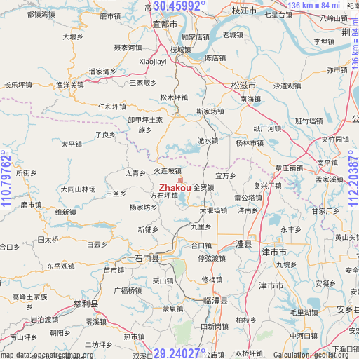
Zhakou GPS coordinates[2]
29° 51' 7.056" North, 111° 30' 2.664" East
| Map corner | latitude | longitude |
|---|---|---|
| Upper-left | 30.45992°, | 110.79762° |
| Center: | 29.85196°, | 111.50074° |
| Lower-right: | 29.24027°, | 112.20387° |
| Map W x H: | 135.6×135.6 km | = 84.3×84.3mi |
| max Lat: | 53.31946° ⇑55.7% North |
| Zhakou: | 29.85196° |
| min Lat: | ⇓44.3% South 18.22056° |
| min Long | Zhakou | max Long |
| 75.07348° | 111.50074° | 134.28917° |
| W 35%⇐ | ⇒65% E |
Elevation
Elevation of Zhakou is 86 m = 282 ft, and this is 398.8 m = 1308 ft below average elevation for this country.
| Max E: |
5622 m = 18445 ft | 62.3% |
| Avg. | 484.8 m = 1591 ft | |
| Zhakou | 86 m = 282 ft | |
Min E: |
-3 m = -10 ft | 37.7% |
See also: China elevation on elevation.city.
Geographical zone
Zhakou is located in North temperate zone (between Tropic of Cancer and the Arctic Circle). Distance of this Northern Tropic circle is 713.3 km =443.2 mi to South.| Distance of | km | miles | from Zhakou |
|---|---|---|---|
| North Pole | 6687.8 | 4155.6 | to North |
| Arctic Circle | 4081.9 | 2536.4 | to North |
| Tropic Cancer | 713.3 | 443.2 | to South |
| Equator | 3319.2 | 2062.5 | to South |


Nearby cities:
15 places around Zhakou: (largest is in red/bold)
• Dayandang
17.1 km =10.6 mi,  131°
131°
• Dongshi
13 km =8.1 mi,  248°
248°
• Fangshiping
8.3 km =5.2 mi,  227°
227°
• Ganxitan
12.2 km =7.6 mi,  278°
278°
• Guanting
16.3 km =10.1 mi,  164°
164°
• Huolianpo
5.8 km =3.6 mi,  307°
307°
• Jinluo
10.5 km =6.5 mi,  116°
116°
• Jiuli
19.3 km =12 mi,  154°
154°
• Matoupu
12.4 km =7.7 mi,  223°
223°
• Taiqing
18.3 km =11.4 mi, 278°
• Wangjiachang
10.6 km =6.6 mi, 162°
• Weishui
18.4 km =11.4 mi,  35°
35°
• Yangjiafang
17.5 km =10.9 mi, 232°
• Yiwan
17.5 km =10.9 mi,  84°
84°
• Zhongwu
18.7 km =11.6 mi, 117°
Sources, notices
• [Note1] Compared only with cities in China existing in our database
• [Src1] Map data: © OpenStreetMap contributors (CC-BY-SA)
• [Src2] Other city data from geonames.org with taken over terms of usage.
• [Src3] Geographical zone / Annual Mean Temperature by Robert A. Rohde @ Wikipedia
