Weishui geodata
Weishui (Hubei) is a seat of a fourth-order administrative division; located in China in Asia/Shanghai (GMT+8) time zone. In our database, there are 1268 cities with bigger population. Compared to other cities in China, 54.2% of cities are located further ↑North; 64.5% of cities are located further →East and 66.6% of cities have higher elevation than Weishui. Note1


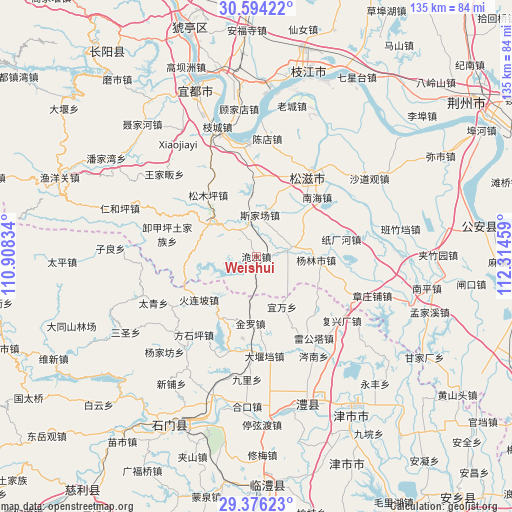
Weishui GPS coordinates[2]
29° 59' 13.524" North, 111° 36' 41.256" East
| Map corner | latitude | longitude |
|---|---|---|
| Upper-left | 30.59422°, | 110.90834° |
| Center: | 29.98709°, | 111.61146° |
| Lower-right: | 29.37623°, | 112.31459° |
| Map W x H: | 135.4×135.4 km | = 84.1×84.1mi |
| max Lat: | 53.31946° ⇑54.2% North |
| Weishui: | 29.98709° |
| min Lat: | ⇓45.8% South 18.22056° |
| min Long | Weishui | max Long |
| 75.07348° | 111.61146° | 134.28917° |
| W 35.5%⇐ | ⇒64.5% E |
Elevation
Elevation of Weishui is 66 m = 217 ft, and this is 418.8 m = 1374 ft below average elevation for this country.
| Max E: |
5622 m = 18445 ft | 66.6% |
| Avg. | 484.8 m = 1591 ft | |
| Weishui | 66 m = 217 ft | |
Min E: |
-3 m = -10 ft | 33.4% |
See also: China elevation on elevation.city.
Geographical zone
Weishui is located in North temperate zone (between Tropic of Cancer and the Arctic Circle). Distance of this Northern Tropic circle is 728.3 km =452.5 mi to South.| Distance of | km | miles | from Weishui |
|---|---|---|---|
| North Pole | 6672.8 | 4146.3 | to North |
| Arctic Circle | 4066.9 | 2527.1 | to North |
| Tropic Cancer | 728.3 | 452.5 | to South |
| Equator | 3334.3 | 2071.8 | to South |


Nearby cities:
15 places around Weishui: (largest is in red/bold)
• Huolianpo
19.1 km =11.9 mi,  232°
232°
• Jieheshi
10.4 km =6.5 mi,  73°
73°
• Jinluo
19.8 km =12.3 mi,  183°
183°
• Liujiachang
15.8 km =9.8 mi,  301°
301°
• Nanhai
22.5 km =14 mi,  45°
45°
• Sijiachang
11 km =6.8 mi,  4°
4°
• Songmuping
20.7 km =12.9 mi,  321°
321°
• Wangjiaqiao
17.4 km =10.8 mi,  19°
19°
• Wanjia
8.3 km =5.2 mi,  104°
104°
• Yanglinshi
15.8 km =9.8 mi,  93°
93°
• Yanjing
21.5 km =13.4 mi,  138°
138°
• Yiwan
14.9 km =9.3 mi,  153°
153°
• Zhakou
18.4 km =11.4 mi,  215°
215°
• Zhichanghe
22.9 km =14.2 mi,  78°
78°
• Zhongwu
24.3 km =15.1 mi,  166°
166°
Sources, notices
• [Note1] Compared only with cities in China existing in our database
• [Src1] Map data: © OpenStreetMap contributors (CC-BY-SA)
• [Src2] Other city data from geonames.org with taken over terms of usage.
• [Src3] Geographical zone / Annual Mean Temperature by Robert A. Rohde @ Wikipedia
