Guwei geodata
Guwei (Shanxi) is a seat of a third-order administrative division; located in China in Asia/Shanghai (GMT+8) time zone. In our database, there are 1268 cities with bigger population. Compared to other cities in China, 73.8% of cities are located further ↓South; 68.5% of cities are located further →East and 76.6% of cities have lower elevation than Guwei. Note1


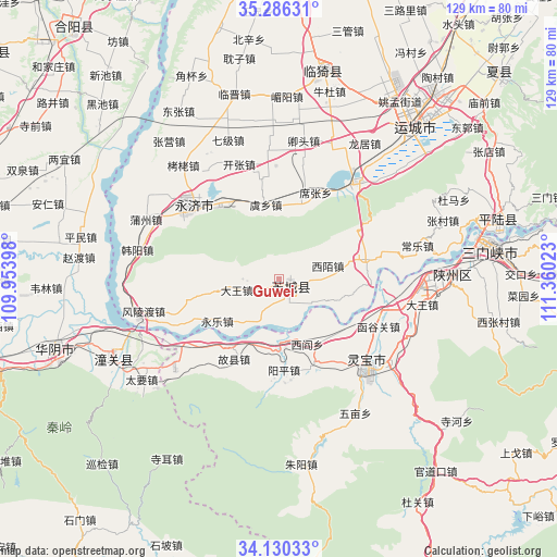
Guwei GPS coordinates[2]
34° 42' 37.224" North, 110° 39' 25.56" East
| Map corner | latitude | longitude |
|---|---|---|
| Upper-left | 35.28631°, | 109.95398° |
| Center: | 34.71034°, | 110.6571° |
| Lower-right: | 34.13033°, | 111.36023° |
| Map W x H: | 128.5×128.5 km | = 79.8×79.8mi |
| max Lat: | 53.31946° ⇑26.2% North |
| Guwei: | 34.71034° |
| min Lat: | ⇓73.8% South 18.22056° |
| min Long | Guwei | max Long |
| 75.07348° | 110.6571° | 134.28917° |
| W 31.5%⇐ | ⇒68.5% E |
Elevation
Elevation of Guwei is 565 m = 1854 ft, and this is 80.2 m = 263 ft above average elevation for this country.
| Max E: |
5622 m = 18445 ft | 23.4% |
| Guwei | 565 m 1854 ft | |
| Avg. | 484.8 m = 1591 ft | |
Min E: |
-3 m = -10 ft | 76.6% |
See also: China elevation on elevation.city.
Geographical zone
Guwei is located in North temperate zone (between Tropic of Cancer and the Arctic Circle). Distance of this Northern Tropic circle is 1253.5 km =778.9 mi to South.| Distance of | km | miles | from Guwei |
|---|---|---|---|
| North Pole | 6147.6 | 3819.9 | to North |
| Arctic Circle | 3541.7 | 2200.7 | to North |
| Tropic Cancer | 1253.5 | 778.9 | to South |
| Equator | 3859.4 | 2398.1 | to South |


Nearby cities:
15 places around Guwei: (largest is in red/bold)
• Anyi
51.6 km =32.1 mi,  41°
41°
• Boshi
55.8 km =34.7 mi,  276°
276°
• Dali
66.3 km =41.2 mi, 278°
• Daying
40.8 km =25.4 mi,  88°
88°
• Fushui
66.9 km =41.6 mi,  254°
254°
• Guanchi
65.5 km =40.7 mi,  269°
269°
• Huayin
56.4 km =35 mi, 253°
• Lingbao Chengguanzhen
28.4 km =17.6 mi,  138°
138°
• Shengrenjian
51 km =31.7 mi,  73°
73°
• Shicao
65.6 km =40.8 mi, 273°
• Taoxia
64.8 km =40.3 mi, 253°
• Xizhai
55.6 km =34.5 mi, 267°
• Xuzhuang
67.6 km =42 mi, 284°
• Yishi
51.2 km =31.8 mi,  9°
9°
• Yuncheng
46.3 km =28.8 mi, 41°
Sources, notices
• [Note1] Compared only with cities in China existing in our database
• [Src1] Map data: © OpenStreetMap contributors (CC-BY-SA)
• [Src2] Other city data from geonames.org with taken over terms of usage.
• [Src3] Geographical zone / Annual Mean Temperature by Robert A. Rohde @ Wikipedia
