Youxi geodata
Youxi (Zhejiang) is a seat of a fourth-order administrative division; located in China in Asia/Shanghai (GMT+8) time zone. In our database, there are 1268 cities with bigger population. Compared to other cities in China, 67.5% of cities are located further ↑North; 88.2% of cities are located further ←West and 83.9% of cities have higher elevation than Youxi. Note1


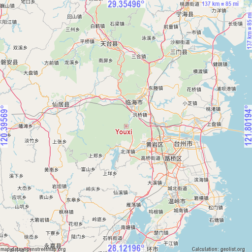
Youxi GPS coordinates[2]
28° 44' 25.008" North, 121° 5' 55.716" East
| Map corner | latitude | longitude |
|---|---|---|
| Upper-left | 29.35496°, | 120.39569° |
| Center: | 28.74028°, | 121.09881° |
| Lower-right: | 28.12196°, | 121.80194° |
| Map W x H: | 137.1×137.1 km | = 85.2×85.2mi |
| max Lat: | 53.31946° ⇑67.5% North |
| Youxi: | 28.74028° |
| min Lat: | ⇓32.5% South 18.22056° |
| min Long | Youxi | max Long |
| 75.07348° | 121.09881° | 134.28917° |
| W 88.2%⇐ | ⇒11.8% E |
Elevation
Elevation of Youxi is 18 m = 59 ft, and this is 466.8 m = 1531 ft below average elevation for this country.
| Max E: |
5622 m = 18445 ft | 83.9% |
| Avg. | 484.8 m = 1591 ft | |
| Youxi | 18 m = 59 ft | |
Min E: |
-3 m = -10 ft | 16.1% |
See also: China elevation on elevation.city.
Geographical zone
Youxi is located in North temperate zone (between Tropic of Cancer and the Arctic Circle). Distance of this Northern Tropic circle is 589.7 km =366.4 mi to South.| Distance of | km | miles | from Youxi |
|---|---|---|---|
| North Pole | 6811.4 | 4232.4 | to North |
| Arctic Circle | 4205.6 | 2613.2 | to North |
| Tropic Cancer | 589.7 | 366.4 | to South |
| Equator | 3195.6 | 1985.7 | to South |


Nearby cities:
15 places around Youxi: (largest is in red/bold)
• Beicheng
17.2 km =10.7 mi,  115°
115°
• Beiyang
13.8 km =8.6 mi,  176°
176°
• Dayang
15.1 km =9.4 mi,  20°
20°
• Dengjiang
16 km =9.9 mi,  140°
140°
• Gucheng
12.2 km =7.6 mi,  7°
7°
• Jiangnan
10.4 km =6.5 mi, 13°
• Kuocang
17.4 km =10.8 mi,  319°
319°
• Linhai
13.6 km =8.5 mi, 19°
• Maoshe
18.3 km =11.4 mi,  172°
172°
• Toutuo
12.9 km =8 mi,  160°
160°
• Xinqian
14.1 km =8.8 mi,  130°
130°
• Xunqiao
9.5 km =5.9 mi,  48°
48°
• Yanjiang
13.4 km =8.3 mi,  88°
88°
• Yongfeng
17.5 km =10.9 mi,  350°
350°
• Yutou
14.3 km =8.9 mi,  220°
220°
Sources, notices
• [Note1] Compared only with cities in China existing in our database
• [Src1] Map data: © OpenStreetMap contributors (CC-BY-SA)
• [Src2] Other city data from geonames.org with taken over terms of usage.
• [Src3] Geographical zone / Annual Mean Temperature by Robert A. Rohde @ Wikipedia
