Linhai geodata
Linhai (Zhejiang) is a seat of a third-order administrative division; located in China in Asia/Shanghai (GMT+8) time zone. With population of 152,937 people, there are 288 cities with bigger population in this country. Compared to other cities in China, 66.7% of cities are located further ↑North; 88.4% of cities are located further ←West and 86.9% of cities have higher elevation than Linhai. Note1


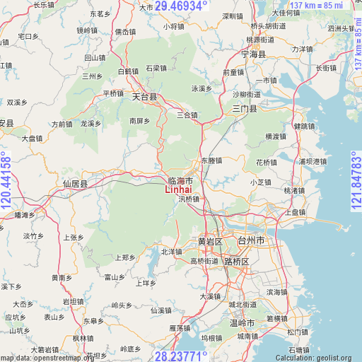
Linhai GPS coordinates[2]
28° 51' 19.26" North, 121° 8' 40.92" East
| Map corner | latitude | longitude |
|---|---|---|
| Upper-left | 29.46934°, | 120.44158° |
| Center: | 28.85535°, | 121.1447° |
| Lower-right: | 28.23771°, | 121.84783° |
| Map W x H: | 136.9×136.9 km | = 85.1×85.1mi |
| max Lat: | 53.31946° ⇑66.7% North |
| Linhai: | 28.85535° |
| min Lat: | ⇓33.3% South 18.22056° |
| min Long | Linhai | max Long |
| 75.07348° | 121.1447° | 134.28917° |
| W 88.4%⇐ | ⇒11.6% E |
Elevation
Elevation of Linhai is 13 m = 43 ft, and this is 471.8 m = 1548 ft below average elevation for this country.
| Max E: |
5622 m = 18445 ft | 86.9% |
| Avg. | 484.8 m = 1591 ft | |
| Linhai | 13 m = 43 ft | |
Min E: |
-3 m = -10 ft | 13.1% |
See also: Linhai elevation on elevation.city.
Geographical zone
Linhai is located in North temperate zone (between Tropic of Cancer and the Arctic Circle). Distance of this Northern Tropic circle is 602.5 km =374.4 mi to South.| Distance of | km | miles | from Linhai |
|---|---|---|---|
| North Pole | 6798.6 | 4224.5 | to North |
| Arctic Circle | 4192.8 | 2605.3 | to North |
| Tropic Cancer | 602.5 | 374.4 | to South |
| Equator | 3208.4 | 1993.6 | to South |


Nearby cities:
15 places around Linhai: (largest is in red/bold)
• Dacun
22.9 km =14.2 mi,  13°
13°
• Datian
7.8 km =4.8 mi,  41°
41°
• Dayang
1.6 km =1 mi,  28°
28°
• Dongcheng
14.7 km =9.1 mi,  56°
56°
• Gucheng
2.9 km =1.8 mi,  254°
254°
• Hetou
16.4 km =10.2 mi,  342°
342°
• Huixi
13.3 km =8.3 mi, 29°
• Jiangnan
3.4 km =2.1 mi,  216°
216°
• Kuocang
15.8 km =9.8 mi,  271°
271°
• Xinqian
22.8 km =14.2 mi,  164°
164°
• Xunqiao
7 km =4.3 mi, 157°
• Yanjiang
15.3 km =9.5 mi,  144°
144°
• Yongfeng
8.7 km =5.4 mi,  301°
301°
• Yongquan
19.8 km =12.3 mi,  121°
121°
• Youxi
13.6 km =8.5 mi,  199°
199°
Sources, notices
• [Note1] Compared only with cities in China existing in our database
• [Src1] Map data: © OpenStreetMap contributors (CC-BY-SA)
• [Src2] Other city data from geonames.org with taken over terms of usage.
• [Src3] Geographical zone / Annual Mean Temperature by Robert A. Rohde @ Wikipedia
