Hedong geodata
Hedong (Guangdong) is a seat of a fourth-order administrative division; located in China in Asia/Shanghai (GMT+8) time zone. In our database, there are 1268 cities with bigger population. Compared to other cities in China, 87.4% of cities are located further ↑North; 62.3% of cities are located further →East and 74.7% of cities have lower elevation than Hedong. Note1


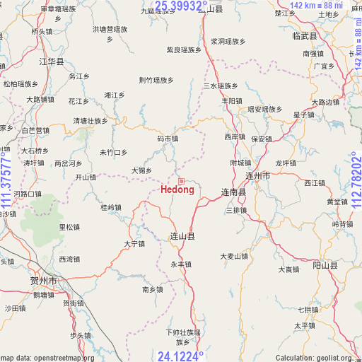
Hedong GPS coordinates[2]
24° 45' 45" North, 112° 4' 44.004" East
| Map corner | latitude | longitude |
|---|---|---|
| Upper-left | 25.39932°, | 111.37577° |
| Center: | 24.7625°, | 112.07889° |
| Lower-right: | 24.1224°, | 112.78202° |
| Map W x H: | 142×142 km | = 88.2×88.2mi |
| max Lat: | 53.31946° ⇑87.4% North |
| Hedong: | 24.7625° |
| min Lat: | ⇓12.6% South 18.22056° |
| min Long | Hedong | max Long |
| 75.07348° | 112.07889° | 134.28917° |
| W 37.7%⇐ | ⇒62.3% E |
Elevation
Elevation of Hedong is 516 m = 1693 ft, and this is 31.2 m = 102 ft above average elevation for this country.
| Max E: |
5622 m = 18445 ft | 25.3% |
| Hedong | 516 m 1693 ft | |
| Avg. | 484.8 m = 1591 ft | |
Min E: |
-3 m = -10 ft | 74.7% |
See also: China elevation on elevation.city.
Geographical zone
Hedong is located in North temperate zone (between Tropic of Cancer and the Arctic Circle). Distance of this Northern Tropic circle is 147.4 km =91.6 mi to South.| Distance of | km | miles | from Hedong |
|---|---|---|---|
| North Pole | 7253.7 | 4507.2 | to North |
| Arctic Circle | 4647.8 | 2888 | to North |
| Tropic Cancer | 147.4 | 91.6 | to South |
| Equator | 2753.3 | 1710.8 | to South |


Nearby cities:
15 places around Hedong: (largest is in red/bold)
• Bao’an
35.5 km =22.1 mi,  61°
61°
• Dafu
13 km =8.1 mi,  190°
190°
• Damaishan
36 km =22.4 mi,  147°
147°
• Daping
14.7 km =9.1 mi, 147°
• Dongbei
33.6 km =20.9 mi,  40°
40°
• Jitian
21.2 km =13.2 mi,  180°
180°
• Jiubei
30.8 km =19.1 mi,  109°
109°
• Lianzhou
29.6 km =18.4 mi,  85°
85°
• Sanjiang
22.3 km =13.9 mi,  102°
102°
• Sanpai
23.8 km =14.8 mi,  119°
119°
• Taibao
13.1 km =8.1 mi,  130°
130°
• Woshui
25.9 km =16.1 mi, 145°
• Xiangping
19.8 km =12.3 mi,  166°
166°
• Xi’an
27.5 km =17.1 mi,  50°
50°
• Yonghe
16.9 km =10.5 mi,  195°
195°
Sources, notices
• [Note1] Compared only with cities in China existing in our database
• [Src1] Map data: © OpenStreetMap contributors (CC-BY-SA)
• [Src2] Other city data from geonames.org with taken over terms of usage.
• [Src3] Geographical zone / Annual Mean Temperature by Robert A. Rohde @ Wikipedia
