Lianzhou geodata
Lianzhou (Guangdong) is a seat of a third-order administrative division; located in China in Asia/Shanghai (GMT+8) time zone. With population of 92,827 people, there are 456 cities with bigger population in this country. Compared to other cities in China, 87.3% of cities are located further ↑North; 60.7% of cities are located further →East and 59.9% of cities have higher elevation than Lianzhou. Note1


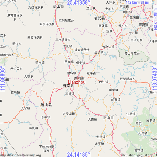
Lianzhou GPS coordinates[2]
24° 46' 54.696" North, 112° 22' 16.32" East
| Map corner | latitude | longitude |
|---|---|---|
| Upper-left | 25.41858°, | 111.66808° |
| Center: | 24.78186°, | 112.3712° |
| Lower-right: | 24.14185°, | 113.07433° |
| Map W x H: | 142×142 km | = 88.2×88.2mi |
| max Lat: | 53.31946° ⇑87.3% North |
| Lianzhou: | 24.78186° |
| min Lat: | ⇓12.7% South 18.22056° |
| min Long | Lianzhou | max Long |
| 75.07348° | 112.3712° | 134.28917° |
| W 39.3%⇐ | ⇒60.7% E |
Elevation
Elevation of Lianzhou is 99 m = 325 ft, and this is 385.8 m = 1266 ft below average elevation for this country.
| Max E: |
5622 m = 18445 ft | 59.9% |
| Avg. | 484.8 m = 1591 ft | |
| Lianzhou | 99 m = 325 ft | |
Min E: |
-3 m = -10 ft | 40.1% |
See also: Lianzhou elevation on elevation.city.
Geographical zone
Lianzhou is located in North temperate zone (between Tropic of Cancer and the Arctic Circle). Distance of this Northern Tropic circle is 149.6 km =93 mi to South.| Distance of | km | miles | from Lianzhou |
|---|---|---|---|
| North Pole | 7251.6 | 4505.9 | to North |
| Arctic Circle | 4645.7 | 2886.7 | to North |
| Tropic Cancer | 149.6 | 93 | to South |
| Equator | 2755.5 | 1712.2 | to South |


Nearby cities:
15 places around Lianzhou: (largest is in red/bold)
• Bao’an
15.1 km =9.4 mi,  5°
5°
• Daping
26 km =16.2 mi,  236°
236°
• Dongbei
24.5 km =15.2 mi,  341°
341°
• Hedong
29.6 km =18.4 mi,  265°
265°
• Jiubei
12.5 km =7.8 mi,  182°
182°
• Libu
25.4 km =15.8 mi,  169°
169°
• Longping
11.6 km =7.2 mi,  68°
68°
• Sanjiang
10.3 km =6.4 mi,  228°
228°
• Sanpai
16.5 km =10.3 mi,  212°
212°
• Taibao
22.3 km =13.9 mi, 241°
• Woshui
27.6 km =17.1 mi, 212°
• Xiaojiang
29.3 km =18.2 mi,  129°
129°
• Xijiang
21.7 km =13.5 mi,  98°
98°
• Xi’an
17.5 km =10.9 mi,  331°
331°
• Yao’an
26.7 km =16.6 mi, 7°
Sources, notices
• [Note1] Compared only with cities in China existing in our database
• [Src1] Map data: © OpenStreetMap contributors (CC-BY-SA)
• [Src2] Other city data from geonames.org with taken over terms of usage.
• [Src3] Geographical zone / Annual Mean Temperature by Robert A. Rohde @ Wikipedia
