Yongchang geodata
Yongchang (Zhejiang) is a seat of a fourth-order administrative division; located in China in Asia/Shanghai (GMT+8) time zone. In our database, there are 1268 cities with bigger population. Compared to other cities in China, 62.9% of cities are located further ↑North; 77.9% of cities are located further ←West and 72.7% of cities have higher elevation than Yongchang. Note1


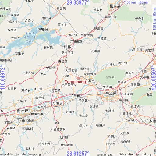
Yongchang GPS coordinates[2]
29° 13' 40.836" North, 119° 21' 10.224" East
| Map corner | latitude | longitude |
|---|---|---|
| Upper-left | 29.83977°, | 118.64972° |
| Center: | 29.22801°, | 119.35284° |
| Lower-right: | 28.61257°, | 120.05597° |
| Map W x H: | 136.5×136.5 km | = 84.8×84.8mi |
| max Lat: | 53.31946° ⇑62.9% North |
| Yongchang: | 29.22801° |
| min Lat: | ⇓37.1% South 18.22056° |
| min Long | Yongchang | max Long |
| 75.07348° | 119.35284° | 134.28917° |
| W 77.9%⇐ | ⇒22.1% E |
Elevation
Elevation of Yongchang is 43 m = 141 ft, and this is 441.8 m = 1449 ft below average elevation for this country.
| Max E: |
5622 m = 18445 ft | 72.7% |
| Avg. | 484.8 m = 1591 ft | |
| Yongchang | 43 m = 141 ft | |
Min E: |
-3 m = -10 ft | 27.3% |
See also: China elevation on elevation.city.
Geographical zone
Yongchang is located in North temperate zone (between Tropic of Cancer and the Arctic Circle). Distance of this Northern Tropic circle is 643.9 km =400.1 mi to South.| Distance of | km | miles | from Yongchang |
|---|---|---|---|
| North Pole | 6757.2 | 4198.7 | to North |
| Arctic Circle | 4151.3 | 2579.5 | to North |
| Tropic Cancer | 643.9 | 400.1 | to South |
| Equator | 3249.9 | 2019.4 | to South |


Nearby cities:
15 places around Yongchang: (largest is in red/bold)
• Hengshan
15.2 km =9.4 mi,  249°
249°
• Houren
5.9 km =3.7 mi,  39°
39°
• Huzhen
19.1 km =11.9 mi,  198°
198°
• Lanjiang
10.6 km =6.6 mi,  97°
97°
• Lanxi
11.6 km =7.2 mi, 96°
• Nübu
11.2 km =7 mi,  69°
69°
• Shouchang
19.7 km =12.2 mi,  318°
318°
• Shuiting
9.5 km =5.9 mi,  235°
235°
• Tangcun
8.3 km =5.2 mi, 321°
• Tangxi
20 km =12.4 mi,  167°
167°
• Tashi
21.5 km =13.4 mi, 242°
• Xiangxi
18.6 km =11.6 mi, 69°
• Yangbu
14.9 km =9.3 mi,  188°
188°
• Zhitang
11 km =6.8 mi,  281°
281°
• Zhuge
6.6 km =4.1 mi,  293°
293°
Sources, notices
• [Note1] Compared only with cities in China existing in our database
• [Src1] Map data: © OpenStreetMap contributors (CC-BY-SA)
• [Src2] Other city data from geonames.org with taken over terms of usage.
• [Src3] Geographical zone / Annual Mean Temperature by Robert A. Rohde @ Wikipedia
