Lanxi geodata
Lanxi (Zhejiang) is a populated place; located in China in Asia/Shanghai (GMT+8) time zone. With population of 73,706 people, there are 581 cities with bigger population in this country. Compared to other cities in China, 63.1% of cities are located further ↑North; 78.6% of cities are located further ←West and 74.4% of cities have higher elevation than Lanxi. Note1


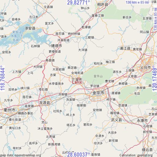
Lanxi GPS coordinates[2]
29° 12' 57.168" North, 119° 28' 17.616" East
| Map corner | latitude | longitude |
|---|---|---|
| Upper-left | 29.82771°, | 118.76844° |
| Center: | 29.21588°, | 119.47156° |
| Lower-right: | 28.60037°, | 120.17469° |
| Map W x H: | 136.5×136.5 km | = 84.8×84.8mi |
| max Lat: | 53.31946° ⇑63.1% North |
| Lanxi: | 29.21588° |
| min Lat: | ⇓36.9% South 18.22056° |
| min Long | Lanxi | max Long |
| 75.07348° | 119.47156° | 134.28917° |
| W 78.6%⇐ | ⇒21.4% E |
Elevation
Elevation of Lanxi is 38 m = 125 ft, and this is 446.8 m = 1466 ft below average elevation for this country.
| Max E: |
5622 m = 18445 ft | 74.4% |
| Avg. | 484.8 m = 1591 ft | |
| Lanxi | 38 m = 125 ft | |
Min E: |
-3 m = -10 ft | 25.6% |
See also: Lanxi elevation on elevation.city.
Geographical zone
Lanxi is located in North temperate zone (between Tropic of Cancer and the Arctic Circle). Distance of this Northern Tropic circle is 642.6 km =399.3 mi to South.| Distance of | km | miles | from Lanxi |
|---|---|---|---|
| North Pole | 6758.6 | 4199.6 | to North |
| Arctic Circle | 4152.7 | 2580.4 | to North |
| Tropic Cancer | 642.6 | 399.3 | to South |
| Equator | 3248.5 | 2018.5 | to South |


Nearby cities:
15 places around Lanxi: (largest is in red/bold)
• Bailongqiao
17.1 km =10.6 mi,  154°
154°
• Chengzhong
21.1 km =13.1 mi,  125°
125°
• Houren
9.7 km =6 mi,  307°
307°
• Jinhua
20.7 km =12.9 mi, 125°
• Lanjiang
1 km =0.6 mi,  265°
265°
• Luodian
15.1 km =9.4 mi,  113°
113°
• Nübu
5.3 km =3.3 mi,  348°
348°
• Qiubin
20.9 km =13 mi,  139°
139°
• Shuiting
19.7 km =12.2 mi,  258°
258°
• Tangcun
18.5 km =11.5 mi,  295°
295°
• Tangxi
19.5 km =12.1 mi,  201°
201°
• Xiangxi
9.9 km =6.2 mi,  36°
36°
• Yangbu
19.2 km =11.9 mi,  225°
225°
• Yongchang
11.6 km =7.2 mi,  276°
276°
• Zhuge
18 km =11.2 mi, 282°
Sources, notices
• [Note1] Compared only with cities in China existing in our database
• [Src1] Map data: © OpenStreetMap contributors (CC-BY-SA)
• [Src2] Other city data from geonames.org with taken over terms of usage.
• [Src3] Geographical zone / Annual Mean Temperature by Robert A. Rohde @ Wikipedia
