Hengshan geodata
Hengshan (Zhejiang) is a seat of a fourth-order administrative division; located in China in Asia/Shanghai (GMT+8) time zone. In our database, there are 1268 cities with bigger population. Compared to other cities in China, 63.5% of cities are located further ↑North; 77.1% of cities are located further ←West and 67.2% of cities have higher elevation than Hengshan. Note1


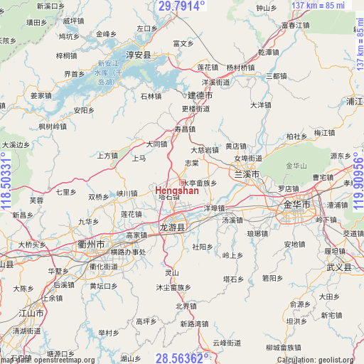
Hengshan GPS coordinates[2]
29° 10' 45.66" North, 119° 12' 23.148" East
| Map corner | latitude | longitude |
|---|---|---|
| Upper-left | 29.7914°, | 118.50331° |
| Center: | 29.17935°, | 119.20643° |
| Lower-right: | 28.56362°, | 119.90956° |
| Map W x H: | 136.5×136.5 km | = 84.8×84.8mi |
| max Lat: | 53.31946° ⇑63.5% North |
| Hengshan: | 29.17935° |
| min Lat: | ⇓36.5% South 18.22056° |
| min Long | Hengshan | max Long |
| 75.07348° | 119.20643° | 134.28917° |
| W 77.1%⇐ | ⇒22.9% E |
Elevation
Elevation of Hengshan is 64 m = 210 ft, and this is 420.8 m = 1381 ft below average elevation for this country.
| Max E: |
5622 m = 18445 ft | 67.2% |
| Avg. | 484.8 m = 1591 ft | |
| Hengshan | 64 m = 210 ft | |
Min E: |
-3 m = -10 ft | 32.8% |
See also: China elevation on elevation.city.
Geographical zone
Hengshan is located in North temperate zone (between Tropic of Cancer and the Arctic Circle). Distance of this Northern Tropic circle is 638.5 km =396.7 mi to South.| Distance of | km | miles | from Hengshan |
|---|---|---|---|
| North Pole | 6762.6 | 4202.1 | to North |
| Arctic Circle | 4156.7 | 2582.9 | to North |
| Tropic Cancer | 638.5 | 396.7 | to South |
| Equator | 3244.4 | 2016 | to South |


Nearby cities:
15 places around Hengshan: (largest is in red/bold)
• Datong
17.5 km =10.9 mi,  326°
326°
• Houren
20.5 km =12.7 mi,  61°
61°
• Huzhen
15.2 km =9.4 mi,  146°
146°
• Longzhou
16.7 km =10.4 mi,  192°
192°
• Shangma
18.8 km =11.7 mi,  299°
299°
• Shifo
9.9 km =6.2 mi,  263°
263°
• Shouchang
20.1 km =12.5 mi,  3°
3°
• Shuiting
6.4 km =4 mi,  90°
90°
• Tangcun
15 km =9.3 mi,  37°
37°
• Tashi
6.6 km =4.1 mi,  228°
228°
• Yangbu
15.2 km =9.4 mi,  127°
127°
• Yongchang
15.2 km =9.4 mi,  69°
69°
• Zhanjia
19.1 km =11.9 mi,  203°
203°
• Zhitang
8.3 km =5.2 mi,  24°
24°
• Zhuge
11.5 km =7.1 mi,  45°
45°
Sources, notices
• [Note1] Compared only with cities in China existing in our database
• [Src1] Map data: © OpenStreetMap contributors (CC-BY-SA)
• [Src2] Other city data from geonames.org with taken over terms of usage.
• [Src3] Geographical zone / Annual Mean Temperature by Robert A. Rohde @ Wikipedia
