Houren geodata
Houren (Zhejiang) is a seat of a fourth-order administrative division; located in China in Asia/Shanghai (GMT+8) time zone. In our database, there are 1268 cities with bigger population. Compared to other cities in China, 62.4% of cities are located further ↑North; 78.1% of cities are located further ←West and 68.2% of cities have higher elevation than Houren. Note1


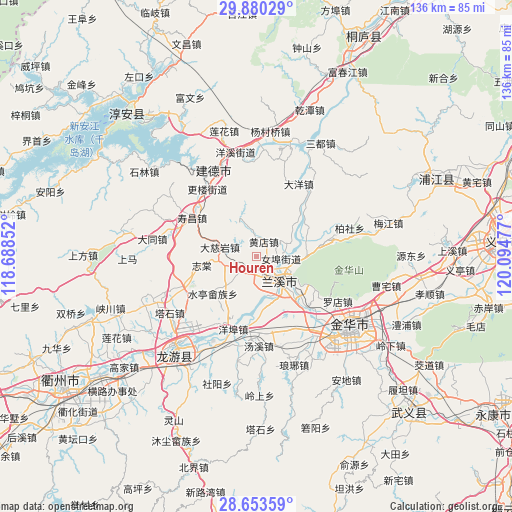
Houren GPS coordinates[2]
29° 16' 7.608" North, 119° 23' 29.904" East
| Map corner | latitude | longitude |
|---|---|---|
| Upper-left | 29.88029°, | 118.68852° |
| Center: | 29.26878°, | 119.39164° |
| Lower-right: | 28.65359°, | 120.09477° |
| Map W x H: | 136.4×136.4 km | = 84.8×84.8mi |
| max Lat: | 53.31946° ⇑62.4% North |
| Houren: | 29.26878° |
| min Lat: | ⇓37.6% South 18.22056° |
| min Long | Houren | max Long |
| 75.07348° | 119.39164° | 134.28917° |
| W 78.1%⇐ | ⇒21.9% E |
Elevation
Elevation of Houren is 59 m = 194 ft, and this is 425.8 m = 1397 ft below average elevation for this country.
| Max E: |
5622 m = 18445 ft | 68.2% |
| Avg. | 484.8 m = 1591 ft | |
| Houren | 59 m = 194 ft | |
Min E: |
-3 m = -10 ft | 31.8% |
See also: China elevation on elevation.city.
Geographical zone
Houren is located in North temperate zone (between Tropic of Cancer and the Arctic Circle). Distance of this Northern Tropic circle is 648.5 km =403 mi to South.| Distance of | km | miles | from Houren |
|---|---|---|---|
| North Pole | 6752.7 | 4195.9 | to North |
| Arctic Circle | 4146.8 | 2576.7 | to North |
| Tropic Cancer | 648.5 | 403 | to South |
| Equator | 3254.4 | 2022.2 | to South |


Nearby cities:
15 places around Houren: (largest is in red/bold)
• Dayang
22.4 km =13.9 mi,  30°
30°
• Hengshan
20.5 km =12.7 mi,  241°
241°
• Lanjiang
9 km =5.6 mi,  131°
131°
• Lanxi
9.7 km =6 mi, 127°
• Luodian
24.7 km =15.3 mi,  118°
118°
• Nübu
6.8 km =4.2 mi,  95°
95°
• Shouchang
19.7 km =12.2 mi,  301°
301°
• Shuiting
15.2 km =9.4 mi,  229°
229°
• Tangcun
9.2 km =5.7 mi,  282°
282°
• Tangxi
24.1 km =15 mi,  178°
178°
• Xiangxi
13.8 km =8.6 mi,  81°
81°
• Yangbu
20.2 km =12.6 mi,  197°
197°
• Yongchang
5.9 km =3.7 mi,  219°
219°
• Zhitang
14.7 km =9.1 mi,  260°
260°
• Zhuge
10 km =6.2 mi, 259°
Sources, notices
• [Note1] Compared only with cities in China existing in our database
• [Src1] Map data: © OpenStreetMap contributors (CC-BY-SA)
• [Src2] Other city data from geonames.org with taken over terms of usage.
• [Src3] Geographical zone / Annual Mean Temperature by Robert A. Rohde @ Wikipedia
