Yinzhen geodata
Yinzhen (Shaanxi) is a seat of a fourth-order administrative division; located in China in Asia/Shanghai (GMT+8) time zone. In our database, there are 1268 cities with bigger population. Compared to other cities in China, 70.5% of cities are located further ↓South; 75.9% of cities are located further →East and 77.2% of cities have lower elevation than Yinzhen. Note1


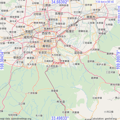
Yinzhen GPS coordinates[2]
34° 4' 57.648" North, 109° 5' 51.576" East
| Map corner | latitude | longitude |
|---|---|---|
| Upper-left | 34.66302°, | 108.39454° |
| Center: | 34.08268°, | 109.09766° |
| Lower-right: | 33.49833°, | 109.80079° |
| Map W x H: | 129.5×129.5 km | = 80.5×80.5mi |
| max Lat: | 53.31946° ⇑29.5% North |
| Yinzhen: | 34.08268° |
| min Lat: | ⇓70.5% South 18.22056° |
| min Long | Yinzhen | max Long |
| 75.07348° | 109.09766° | 134.28917° |
| W 24.1%⇐ | ⇒75.9% E |
Elevation
Elevation of Yinzhen is 580 m = 1903 ft, and this is 95.2 m = 312 ft above average elevation for this country.
| Max E: |
5622 m = 18445 ft | 22.8% |
| Yinzhen | 580 m 1903 ft | |
| Avg. | 484.8 m = 1591 ft | |
Min E: |
-3 m = -10 ft | 77.2% |
See also: China elevation on elevation.city.
Geographical zone
Yinzhen is located in North temperate zone (between Tropic of Cancer and the Arctic Circle). Distance of this Northern Tropic circle is 1183.7 km =735.5 mi to South.| Distance of | km | miles | from Yinzhen |
|---|---|---|---|
| North Pole | 6217.4 | 3863.3 | to North |
| Arctic Circle | 3611.5 | 2244.1 | to North |
| Tropic Cancer | 1183.7 | 735.5 | to South |
| Equator | 3789.6 | 2354.7 | to South |


Nearby cities:
15 places around Yinzhen: (largest is in red/bold)
• Baoli
10.4 km =6.5 mi,  20°
20°
• Dizhai
14.3 km =8.9 mi,  6°
6°
• Duqu
9.3 km =5.8 mi,  288°
288°
• Jiaodai
13.9 km =8.6 mi,  100°
100°
• Mengcun
14.3 km =8.9 mi,  49°
49°
• Mingdu
5.3 km =3.3 mi,  4°
4°
• Qianwei
12.6 km =7.8 mi,  67°
67°
• Shijiazhai
4.8 km =3 mi, 96°
• Taiyigong
10.9 km =6.8 mi,  234°
234°
• Tangyu
12.9 km =8 mi,  123°
123°
• Wangmang
4.8 km =3 mi, 234°
• Wangqu
12.3 km =7.6 mi,  266°
266°
• Weizhai
7.4 km =4.6 mi, 67°
• Wutai
12.8 km =8 mi,  245°
245°
• Yangzhuang
6.1 km =3.8 mi,  139°
139°
Sources, notices
• [Note1] Compared only with cities in China existing in our database
• [Src1] Map data: © OpenStreetMap contributors (CC-BY-SA)
• [Src2] Other city data from geonames.org with taken over terms of usage.
• [Src3] Geographical zone / Annual Mean Temperature by Robert A. Rohde @ Wikipedia
