Jiaodai geodata
Jiaodai (Shaanxi) is a seat of a fourth-order administrative division; located in China in Asia/Shanghai (GMT+8) time zone. In our database, there are 1268 cities with bigger population. Compared to other cities in China, 70.4% of cities are located further ↓South; 75.1% of cities are located further →East and 77.4% of cities have lower elevation than Jiaodai. Note1


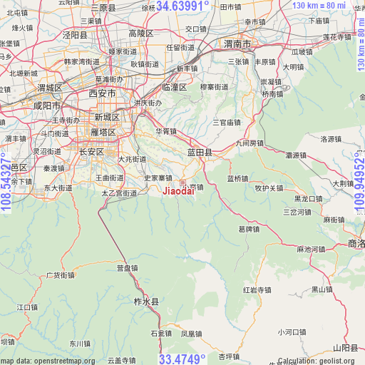
Jiaodai GPS coordinates[2]
34° 3' 33.876" North, 109° 14' 47.004" East
| Map corner | latitude | longitude |
|---|---|---|
| Upper-left | 34.63991°, | 108.54327° |
| Center: | 34.05941°, | 109.24639° |
| Lower-right: | 33.4749°, | 109.94952° |
| Map W x H: | 129.5×129.5 km | = 80.5×80.5mi |
| max Lat: | 53.31946° ⇑29.6% North |
| Jiaodai: | 34.05941° |
| min Lat: | ⇓70.4% South 18.22056° |
| min Long | Jiaodai | max Long |
| 75.07348° | 109.24639° | 134.28917° |
| W 24.9%⇐ | ⇒75.1% E |
Elevation
Elevation of Jiaodai is 587 m = 1926 ft, and this is 102.2 m = 335 ft above average elevation for this country.
| Max E: |
5622 m = 18445 ft | 22.6% |
| Jiaodai | 587 m 1926 ft | |
| Avg. | 484.8 m = 1591 ft | |
Min E: |
-3 m = -10 ft | 77.4% |
See also: China elevation on elevation.city.
Geographical zone
Jiaodai is located in North temperate zone (between Tropic of Cancer and the Arctic Circle). Distance of this Northern Tropic circle is 1181.1 km =733.9 mi to South.| Distance of | km | miles | from Jiaodai |
|---|---|---|---|
| North Pole | 6220 | 3864.9 | to North |
| Arctic Circle | 3614.1 | 2245.7 | to North |
| Tropic Cancer | 1181.1 | 733.9 | to South |
| Equator | 3787.1 | 2353.2 | to South |


Nearby cities:
15 places around Jiaodai: (largest is in red/bold)
• Ancun
7.2 km =4.5 mi,  16°
16°
• Baoli
16 km =9.9 mi,  320°
320°
• Languan
12.6 km =7.8 mi,  29°
29°
• Mengcun
12.2 km =7.6 mi,  346°
346°
• Mingdu
15.4 km =9.6 mi,  300°
300°
• Puhua
17.4 km =10.8 mi,  51°
51°
• Qianwei
7.7 km =4.8 mi,  344°
344°
• Sanli
13.4 km =8.3 mi, 24°
• Shijiazhai
9.2 km =5.7 mi,  283°
283°
• Tangyu
5.4 km =3.4 mi,  212°
212°
• Weizhai
8.7 km =5.4 mi,  307°
307°
• Xiaozhai
4.1 km =2.5 mi,  112°
112°
• Xiehu
16.1 km =10 mi,  359°
359°
• Yangzhuang
10 km =6.2 mi,  258°
258°
• Yinzhen
13.9 km =8.6 mi, 280°
Sources, notices
• [Note1] Compared only with cities in China existing in our database
• [Src1] Map data: © OpenStreetMap contributors (CC-BY-SA)
• [Src2] Other city data from geonames.org with taken over terms of usage.
• [Src3] Geographical zone / Annual Mean Temperature by Robert A. Rohde @ Wikipedia
