Weizhai geodata
Weizhai (Shaanxi) is a seat of a fourth-order administrative division; located in China in Asia/Shanghai (GMT+8) time zone. In our database, there are 1268 cities with bigger population. Compared to other cities in China, 70.7% of cities are located further ↓South; 75.5% of cities are located further →East and 74.7% of cities have lower elevation than Weizhai. Note1


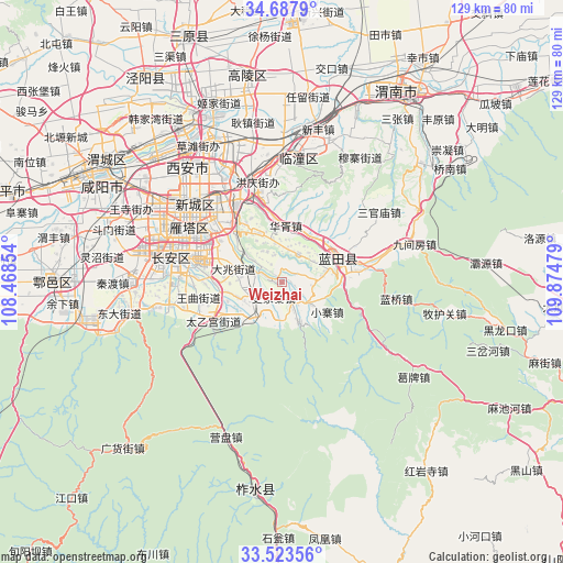
Weizhai GPS coordinates[2]
34° 6' 27.828" North, 109° 10' 17.976" East
| Map corner | latitude | longitude |
|---|---|---|
| Upper-left | 34.6879°, | 108.46854° |
| Center: | 34.10773°, | 109.17166° |
| Lower-right: | 33.52356°, | 109.87479° |
| Map W x H: | 129.5×129.5 km | = 80.5×80.5mi |
| max Lat: | 53.31946° ⇑29.3% North |
| Weizhai: | 34.10773° |
| min Lat: | ⇓70.7% South 18.22056° |
| min Long | Weizhai | max Long |
| 75.07348° | 109.17166° | 134.28917° |
| W 24.5%⇐ | ⇒75.5% E |
Elevation
Elevation of Weizhai is 517 m = 1696 ft, and this is 32.2 m = 106 ft above average elevation for this country.
| Max E: |
5622 m = 18445 ft | 25.3% |
| Weizhai | 517 m 1696 ft | |
| Avg. | 484.8 m = 1591 ft | |
Min E: |
-3 m = -10 ft | 74.7% |
See also: China elevation on elevation.city.
Geographical zone
Weizhai is located in North temperate zone (between Tropic of Cancer and the Arctic Circle). Distance of this Northern Tropic circle is 1186.5 km =737.3 mi to South.| Distance of | km | miles | from Weizhai |
|---|---|---|---|
| North Pole | 6214.6 | 3861.6 | to North |
| Arctic Circle | 3608.8 | 2242.4 | to North |
| Tropic Cancer | 1186.5 | 737.3 | to South |
| Equator | 3792.4 | 2356.5 | to South |


Nearby cities:
15 places around Weizhai: (largest is in red/bold)
• Ancun
9.1 km =5.7 mi,  80°
80°
• Baoli
7.7 km =4.8 mi,  335°
335°
• Dizhai
12.5 km =7.8 mi, 335°
• Huaxu
13.1 km =8.1 mi,  4°
4°
• Jiaodai
8.7 km =5.4 mi,  127°
127°
• Mengcun
7.7 km =4.8 mi,  31°
31°
• Mingdu
6.8 km =4.2 mi,  291°
291°
• Qianwei
5.2 km =3.2 mi,  66°
66°
• Shijiazhai
3.9 km =2.4 mi,  211°
211°
• Tangyu
10.7 km =6.6 mi,  158°
158°
• Wangmang
12 km =7.5 mi,  242°
242°
• Xiaozhai
12.7 km =7.9 mi,  122°
122°
• Xiehu
12.7 km =7.9 mi, 32°
• Yangzhuang
7.9 km =4.9 mi,  201°
201°
• Yinzhen
7.4 km =4.6 mi,  247°
247°
Sources, notices
• [Note1] Compared only with cities in China existing in our database
• [Src1] Map data: © OpenStreetMap contributors (CC-BY-SA)
• [Src2] Other city data from geonames.org with taken over terms of usage.
• [Src3] Geographical zone / Annual Mean Temperature by Robert A. Rohde @ Wikipedia
