Tangyu geodata
Tangyu (Shaanxi) is a seat of a fourth-order administrative division; located in China in Asia/Shanghai (GMT+8) time zone. In our database, there are 1268 cities with bigger population. Compared to other cities in China, 70.1% of cities are located further ↓South; 75.3% of cities are located further →East and 80% of cities have lower elevation than Tangyu. Note1


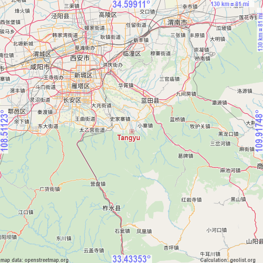
Tangyu GPS coordinates[2]
34° 1' 5.952" North, 109° 12' 51.66" East
| Map corner | latitude | longitude |
|---|---|---|
| Upper-left | 34.59911°, | 108.51123° |
| Center: | 34.01832°, | 109.21435° |
| Lower-right: | 33.43353°, | 109.91748° |
| Map W x H: | 129.6×129.6 km | = 80.5×80.5mi |
| max Lat: | 53.31946° ⇑29.9% North |
| Tangyu: | 34.01832° |
| min Lat: | ⇓70.1% South 18.22056° |
| min Long | Tangyu | max Long |
| 75.07348° | 109.21435° | 134.28917° |
| W 24.7%⇐ | ⇒75.3% E |
Elevation
Elevation of Tangyu is 696 m = 2283 ft, and this is 211.2 m = 693 ft above average elevation for this country.
| Max E: |
5622 m = 18445 ft | 20% |
| Tangyu | 696 m 2283 ft | |
| Avg. | 484.8 m = 1591 ft | |
Min E: |
-3 m = -10 ft | 80% |
See also: China elevation on elevation.city.
Geographical zone
Tangyu is located in North temperate zone (between Tropic of Cancer and the Arctic Circle). Distance of this Northern Tropic circle is 1176.6 km =731.1 mi to South.| Distance of | km | miles | from Tangyu |
|---|---|---|---|
| North Pole | 6224.6 | 3867.8 | to North |
| Arctic Circle | 3618.7 | 2248.6 | to North |
| Tropic Cancer | 1176.6 | 731.1 | to South |
| Equator | 3782.5 | 2350.3 | to South |


Nearby cities:
15 places around Tangyu: (largest is in red/bold)
• Ancun
12.5 km =7.8 mi,  23°
23°
• Baoli
18.4 km =11.4 mi,  337°
337°
• Jiaodai
5.4 km =3.4 mi,  32°
32°
• Languan
18 km =11.2 mi, 30°
• Mengcun
16.5 km =10.3 mi,  0°
0°
• Mingdu
16.2 km =10.1 mi,  320°
320°
• Qianwei
12 km =7.5 mi, 4°
• Sanli
18.8 km =11.7 mi, 27°
• Shijiazhai
8.9 km =5.5 mi, 317°
• Taiyigong
19.6 km =12.2 mi,  272°
272°
• Wangmang
15.3 km =9.5 mi,  286°
286°
• Weizhai
10.7 km =6.6 mi, 338°
• Xiaozhai
7.4 km =4.6 mi,  65°
65°
• Yangzhuang
7.3 km =4.5 mi, 290°
• Yinzhen
12.9 km =8 mi,  303°
303°
Sources, notices
• [Note1] Compared only with cities in China existing in our database
• [Src1] Map data: © OpenStreetMap contributors (CC-BY-SA)
• [Src2] Other city data from geonames.org with taken over terms of usage.
• [Src3] Geographical zone / Annual Mean Temperature by Robert A. Rohde @ Wikipedia
