Yaohua geodata
Yaohua (Jiangsu) is a seat of a third-order administrative division; located in China in Asia/Shanghai (GMT+8) time zone. In our database, there are 1268 cities with bigger population. Compared to other cities in China, 62% of cities are located further ↓South; 75.4% of cities are located further ←West and 75.7% of cities have higher elevation than Yaohua. Note1


Yaohua GPS coordinates[2]
32° 7' 17.472" North, 118° 52' 18.12" East
| Map corner | latitude | longitude |
|---|---|---|
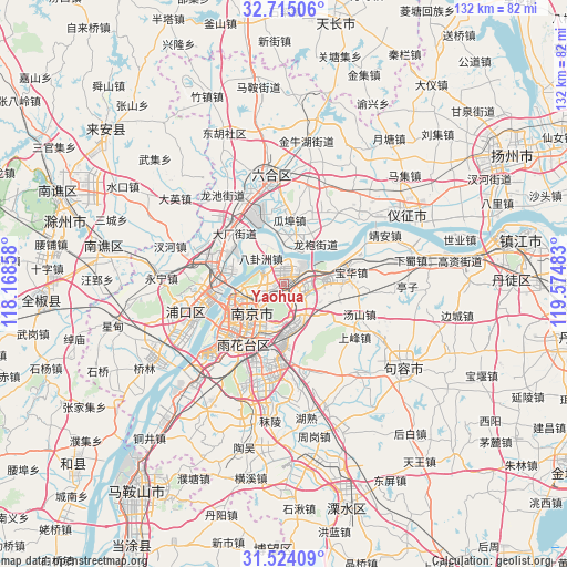
| Upper-left | 32.71506°, | 118.16858° |
| Center: | 32.12152°, | 118.8717° |
| Lower-right: | 31.52409°, | 119.57483° |
| Map W x H: | 132.4×132.4 km | = 82.3×82.3mi |
| max Lat: | 53.31946° ⇑38% North |
| Yaohua: | 32.12152° |
| min Lat: | ⇓62% South 18.22056° |
| min Long | Yaohua | max Long |
| 75.07348° | 118.8717° | 134.28917° |
| W 75.4%⇐ | ⇒24.6% E |
Elevation
Elevation of Yaohua is 35 m = 115 ft, and this is 449.8 m = 1476 ft below average elevation for this country.
| Max E: |
5622 m = 18445 ft | 75.7% |
| Avg. | 484.8 m = 1591 ft | |
| Yaohua | 35 m = 115 ft | |
Min E: |
-3 m = -10 ft | 24.3% |
See also: China elevation on elevation.city.
Geographical zone
Yaohua is located in North temperate zone (between Tropic of Cancer and the Arctic Circle). Distance of this Northern Tropic circle is 965.7 km =600.1 mi to South.| Distance of | km | miles | from Yaohua |
|---|---|---|---|
| North Pole | 6435.5 | 3998.8 | to North |
| Arctic Circle | 3829.6 | 2379.6 | to North |
| Tropic Cancer | 965.7 | 600.1 | to South |
| Equator | 3571.6 | 2219.3 | to South |


Nearby cities:
15 places around Yaohua: (largest is in red/bold)
• Baguazhou
7.8 km =4.8 mi,  318°
318°
• Baotaqiao
11.2 km =7 mi,  266°
266°
• Hongmiao
12.3 km =7.6 mi,  21°
21°
• Longpao
11.3 km =7 mi,  40°
40°
• Ma’qun
7.5 km =4.7 mi,  168°
168°
• Meiyuan Xincun
10.6 km =6.6 mi,  224°
224°
• Mufushan
9.4 km =5.8 mi, 265°
• Nanjing
11.1 km =6.9 mi,  233°
233°
• Qinhong
14.1 km =8.8 mi,  210°
210°
• Qixia
6.9 km =4.3 mi,  73°
73°
• Wulaocun
12 km =7.5 mi, 216°
• Xiaolingwei
10 km =6.2 mi,  189°
189°
• Xiaoshi
8.9 km =5.5 mi,  252°
252°
• Yanziji
5.5 km =3.4 mi,  296°
296°
• Yudai
12 km =7.5 mi,  14°
14°
Sources, notices
• [Note1] Compared only with cities in China existing in our database
• [Src1] Map data: © OpenStreetMap contributors (CC-BY-SA)
• [Src2] Other city data from geonames.org with taken over terms of usage.
• [Src3] Geographical zone / Annual Mean Temperature by Robert A. Rohde @ Wikipedia
