Wulaocun geodata
Wulaocun (Jiangsu) is a seat of a third-order administrative division; located in China in Asia/Shanghai (GMT+8) time zone. In our database, there are 1268 cities with bigger population. Compared to other cities in China, 61.3% of cities are located further ↓South; 75% of cities are located further ←West and 89.9% of cities have higher elevation than Wulaocun. Note1


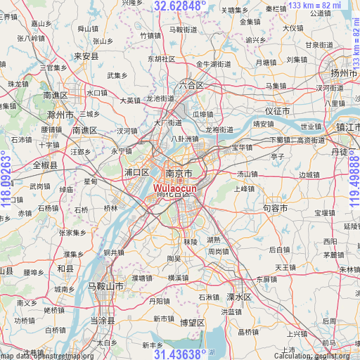
Wulaocun GPS coordinates[2]
32° 2' 3.732" North, 118° 47' 44.7" East
| Map corner | latitude | longitude |
|---|---|---|
| Upper-left | 32.62848°, | 118.09263° |
| Center: | 32.03437°, | 118.79575° |
| Lower-right: | 31.43638°, | 119.49888° |
| Map W x H: | 132.5×132.6 km | = 82.3×82.4mi |
| max Lat: | 53.31946° ⇑38.7% North |
| Wulaocun: | 32.03437° |
| min Lat: | ⇓61.3% South 18.22056° |
| min Long | Wulaocun | max Long |
| 75.07348° | 118.79575° | 134.28917° |
| W 75%⇐ | ⇒25% E |
Elevation
Elevation of Wulaocun is 10 m = 33 ft, and this is 474.8 m = 1558 ft below average elevation for this country.
| Max E: |
5622 m = 18445 ft | 89.9% |
| Avg. | 484.8 m = 1591 ft | |
| Wulaocun | 10 m = 33 ft | |
Min E: |
-3 m = -10 ft | 10.1% |
See also: China elevation on elevation.city.
Geographical zone
Wulaocun is located in North temperate zone (between Tropic of Cancer and the Arctic Circle). Distance of this Northern Tropic circle is 956 km =594 mi to South.| Distance of | km | miles | from Wulaocun |
|---|---|---|---|
| North Pole | 6445.2 | 4004.9 | to North |
| Arctic Circle | 3839.3 | 2385.6 | to North |
| Tropic Cancer | 956 | 594 | to South |
| Equator | 3561.9 | 2213.3 | to South |


Nearby cities:
15 places around Wulaocun: (largest is in red/bold)
• Baotaqiao
9.8 km =6.1 mi,  335°
335°
• Binhu
3.6 km =2.2 mi,  262°
262°
• Dingshan
14.1 km =8.8 mi,  309°
309°
• Dongshan
9.4 km =5.8 mi,  158°
158°
• Jiangxinzhou
9.9 km =6.2 mi,  253°
253°
• Ma’qun
9 km =5.6 mi,  75°
75°
• Meiyuan Xincun
2.2 km =1.4 mi,  352°
352°
• Mufushan
9.2 km =5.7 mi, 346°
• Nanjing
3.5 km =2.2 mi,  330°
330°
• Ningnan
5.6 km =3.5 mi,  193°
193°
• Qinhong
2.6 km =1.6 mi,  178°
178°
• Xiaolingwei
5.5 km =3.4 mi,  92°
92°
• Xiaoshi
7.1 km =4.4 mi, 349°
• Yanziji
12.4 km =7.7 mi,  10°
10°
• Yaohua
12 km =7.5 mi,  36°
36°
Sources, notices
• [Note1] Compared only with cities in China existing in our database
• [Src1] Map data: © OpenStreetMap contributors (CC-BY-SA)
• [Src2] Other city data from geonames.org with taken over terms of usage.
• [Src3] Geographical zone / Annual Mean Temperature by Robert A. Rohde @ Wikipedia
