Ma’qun geodata
Ma’qun (Jiangsu) is a seat of a fourth-order administrative division; located in China in Asia/Shanghai (GMT+8) time zone. In our database, there are 1268 cities with bigger population. Compared to other cities in China, 61.5% of cities are located further ↓South; 75.5% of cities are located further ←West and 80.2% of cities have higher elevation than Ma’qun. Note1


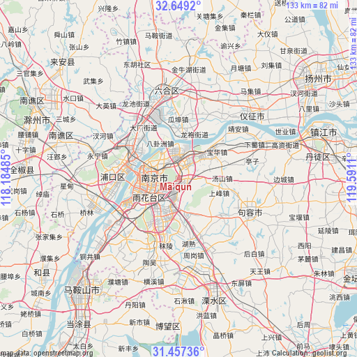
Ma’qun GPS coordinates[2]
32° 3' 18.792" North, 118° 53' 16.692" East
| Map corner | latitude | longitude |
|---|---|---|
| Upper-left | 32.6492°, | 118.18485° |
| Center: | 32.05522°, | 118.88797° |
| Lower-right: | 31.45736°, | 119.5911° |
| Map W x H: | 132.5×132.5 km | = 82.3×82.3mi |
| max Lat: | 53.31946° ⇑38.5% North |
| Ma’qun: | 32.05522° |
| min Lat: | ⇓61.5% South 18.22056° |
| min Long | Ma’qun | max Long |
| 75.07348° | 118.88797° | 134.28917° |
| W 75.5%⇐ | ⇒24.5% E |
Elevation
Elevation of Ma’qun is 26 m = 85 ft, and this is 458.8 m = 1505 ft below average elevation for this country.
| Max E: |
5622 m = 18445 ft | 80.2% |
| Avg. | 484.8 m = 1591 ft | |
| Ma’qun | 26 m = 85 ft | |
Min E: |
-3 m = -10 ft | 19.8% |
See also: China elevation on elevation.city.
Geographical zone
Ma’qun is located in North temperate zone (between Tropic of Cancer and the Arctic Circle). Distance of this Northern Tropic circle is 958.3 km =595.5 mi to South.| Distance of | km | miles | from Ma’qun |
|---|---|---|---|
| North Pole | 6442.9 | 4003.4 | to North |
| Arctic Circle | 3837 | 2384.2 | to North |
| Tropic Cancer | 958.3 | 595.5 | to South |
| Equator | 3564.2 | 2214.7 | to South |


Nearby cities:
15 places around Ma’qun: (largest is in red/bold)
• Baguazhou
14.8 km =9.2 mi,  332°
332°
• Baotaqiao
14.3 km =8.9 mi,  297°
297°
• Binhu
12.6 km =7.8 mi,  257°
257°
• Dongshan
12.2 km =7.6 mi,  205°
205°
• Meiyuan Xincun
9 km =5.6 mi,  269°
269°
• Mufushan
12.7 km =7.9 mi, 301°
• Nanjing
10.4 km =6.5 mi, 273°
• Ningnan
12.7 km =7.9 mi,  232°
232°
• Qinhong
9.9 km =6.2 mi,  240°
240°
• Qixia
10.6 km =6.6 mi,  28°
28°
• Wulaocun
9 km =5.6 mi, 255°
• Xiaolingwei
4.1 km =2.5 mi, 231°
• Xiaoshi
11 km =6.8 mi, 295°
• Yanziji
11.8 km =7.3 mi, 326°
• Yaohua
7.5 km =4.7 mi,  348°
348°
Sources, notices
• [Note1] Compared only with cities in China existing in our database
• [Src1] Map data: © OpenStreetMap contributors (CC-BY-SA)
• [Src2] Other city data from geonames.org with taken over terms of usage.
• [Src3] Geographical zone / Annual Mean Temperature by Robert A. Rohde @ Wikipedia
