Yanmenguan geodata
Yanmenguan (Shanxi) is a seat of a fourth-order administrative division; located in China in Asia/Shanghai (GMT+8) time zone. In our database, there are 1268 cities with bigger population. Compared to other cities in China, 83.7% of cities are located further ↓South; 58.4% of cities are located further →East and 92.3% of cities have lower elevation than Yanmenguan. Note1


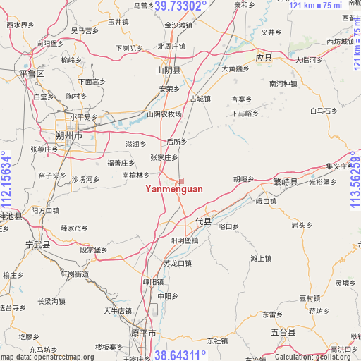
Yanmenguan GPS coordinates[2]
39° 11' 24.648" North, 112° 51' 34.056" East
| Map corner | latitude | longitude |
|---|---|---|
| Upper-left | 39.73302°, | 112.15634° |
| Center: | 39.19018°, | 112.85946° |
| Lower-right: | 38.64311°, | 113.56259° |
| Map W x H: | 121.2×121.2 km | = 75.3×75.3mi |
| max Lat: | 53.31946° ⇑16.3% North |
| Yanmenguan: | 39.19018° |
| min Lat: | ⇓83.7% South 18.22056° |
| min Long | Yanmenguan | max Long |
| 75.07348° | 112.85946° | 134.28917° |
| W 41.6%⇐ | ⇒58.4% E |
Elevation
Elevation of Yanmenguan is 1610 m = 5282 ft, and this is 1125.2 m = 3692 ft above average elevation for this country.
| Max E: |
5622 m = 18445 ft | 7.7% |
| Yanmenguan | 1610 m 5282 ft | |
| Avg. | 484.8 m = 1591 ft | |
Min E: |
-3 m = -10 ft | 92.3% |
See also: China elevation on elevation.city.
Geographical zone
Yanmenguan is located in North temperate zone (between Tropic of Cancer and the Arctic Circle). Distance of this Northern Tropic circle is 1751.6 km =1088.4 mi to South.| Distance of | km | miles | from Yanmenguan |
|---|---|---|---|
| North Pole | 5649.5 | 3510.4 | to North |
| Arctic Circle | 3043.6 | 1891.2 | to North |
| Tropic Cancer | 1751.6 | 1088.4 | to South |
| Equator | 4357.5 | 2707.6 | to South |


Nearby cities:
15 places around Yanmenguan: (largest is in red/bold)
• Fushanzhuang
21.1 km =13.1 mi,  287°
287°
• Housuo
13.5 km =8.4 mi,  354°
354°
• Huyu
21 km =13 mi,  86°
86°
• Mayingzhuang
22.7 km =14.1 mi,  28°
28°
• Nanyulinxi
15.5 km =9.6 mi,  277°
277°
• Nieying
24.6 km =15.3 mi,  106°
106°
• Shangguan
14.8 km =9.2 mi,  155°
155°
• Shangmofang
16.6 km =10.3 mi,  124°
124°
• Xicun
22.5 km =14 mi,  101°
101°
• Xingao
20.3 km =12.6 mi,  154°
154°
• Xuekulue
24.8 km =15.4 mi, 347°
• Yangmingbu
19.8 km =12.3 mi,  176°
176°
• Yukou
22 km =13.7 mi,  133°
133°
• Zhangjiazhuang
9.9 km =6.2 mi,  325°
325°
• Zirun
19.7 km =12.2 mi,  309°
309°
Sources, notices
• [Note1] Compared only with cities in China existing in our database
• [Src1] Map data: © OpenStreetMap contributors (CC-BY-SA)
• [Src2] Other city data from geonames.org with taken over terms of usage.
• [Src3] Geographical zone / Annual Mean Temperature by Robert A. Rohde @ Wikipedia
