Housuo geodata
Housuo (Shanxi) is a seat of a fourth-order administrative division; located in China in Asia/Shanghai (GMT+8) time zone. In our database, there are 1268 cities with bigger population. Compared to other cities in China, 84.1% of cities are located further ↓South; 58.5% of cities are located further →East and 85.9% of cities have lower elevation than Housuo. Note1


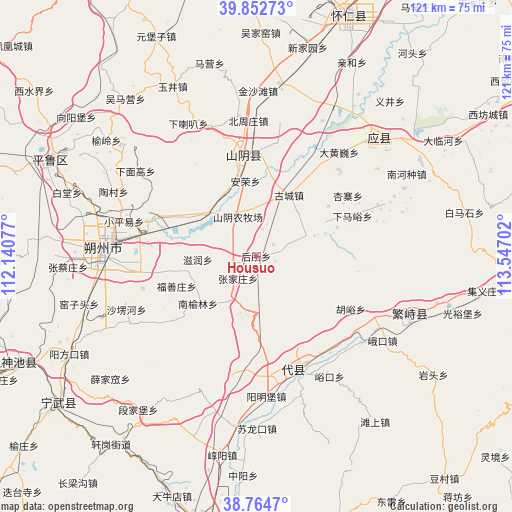
Housuo GPS coordinates[2]
39° 18' 38.988" North, 112° 50' 38.004" East
| Map corner | latitude | longitude |
|---|---|---|
| Upper-left | 39.85273°, | 112.14077° |
| Center: | 39.31083°, | 112.84389° |
| Lower-right: | 38.7647°, | 113.54702° |
| Map W x H: | 121×121 km | = 75.2×75.2mi |
| max Lat: | 53.31946° ⇑15.9% North |
| Housuo: | 39.31083° |
| min Lat: | ⇓84.1% South 18.22056° |
| min Long | Housuo | max Long |
| 75.07348° | 112.84389° | 134.28917° |
| W 41.5%⇐ | ⇒58.5% E |
Elevation
Elevation of Housuo is 1037 m = 3402 ft, and this is 552.2 m = 1812 ft above average elevation for this country.
| Max E: |
5622 m = 18445 ft | 14.1% |
| Housuo | 1037 m 3402 ft | |
| Avg. | 484.8 m = 1591 ft | |
Min E: |
-3 m = -10 ft | 85.9% |
See also: China elevation on elevation.city.
Geographical zone
Housuo is located in North temperate zone (between Tropic of Cancer and the Arctic Circle). Distance of this Northern Tropic circle is 1765 km =1096.7 mi to South.| Distance of | km | miles | from Housuo |
|---|---|---|---|
| North Pole | 5636.1 | 3502.1 | to North |
| Arctic Circle | 3030.2 | 1882.9 | to North |
| Tropic Cancer | 1765 | 1096.7 | to South |
| Equator | 4371 | 2716 | to South |


Nearby cities:
15 places around Housuo: (largest is in red/bold)
• Anrong
17.9 km =11.1 mi,  351°
351°
• Daiyue
23.4 km =14.5 mi, 354°
• Dongshentou
24.2 km =15 mi,  290°
290°
• Fushanzhuang
20.1 km =12.5 mi,  249°
249°
• Gucheng
16.4 km =10.2 mi,  28°
28°
• Huyu
25.4 km =15.8 mi,  118°
118°
• Mayingzhuang
13.8 km =8.6 mi,  61°
61°
• Nanyulinxi
18 km =11.2 mi,  230°
230°
• Shangguan
27.9 km =17.3 mi,  164°
164°
• Shangmofang
27.4 km =17 mi,  146°
146°
• Xiamayu
24.6 km =15.3 mi,  67°
67°
• Xuekulue
11.5 km =7.1 mi,  339°
339°
• Yanmenguan
13.5 km =8.4 mi,  174°
174°
• Zhangjiazhuang
6.8 km =4.2 mi,  219°
219°
• Zirun
13.8 km =8.6 mi,  266°
266°
Sources, notices
• [Note1] Compared only with cities in China existing in our database
• [Src1] Map data: © OpenStreetMap contributors (CC-BY-SA)
• [Src2] Other city data from geonames.org with taken over terms of usage.
• [Src3] Geographical zone / Annual Mean Temperature by Robert A. Rohde @ Wikipedia
