Kuidou geodata
Kuidou (Fujian) is a seat of a fourth-order administrative division; located in China in Asia/Shanghai (GMT+8) time zone. In our database, there are 1268 cities with bigger population. Compared to other cities in China, 85.8% of cities are located further ↑North; 71.3% of cities are located further ←West and 66.8% of cities have higher elevation than Kuidou. Note1


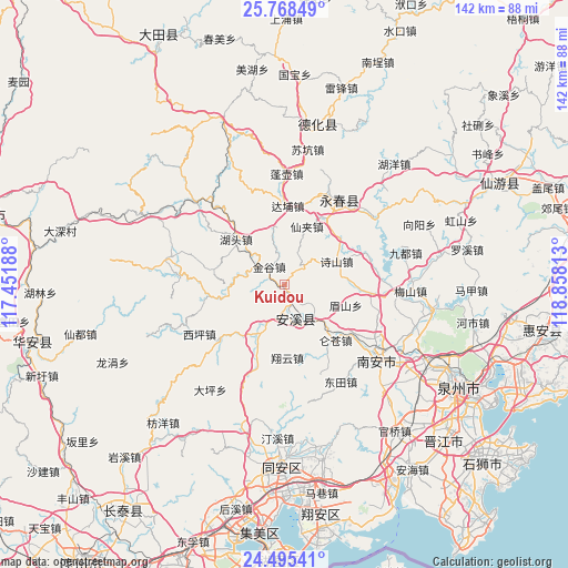
Kuidou GPS coordinates[2]
25° 8' 0.996" North, 118° 9' 18" East
| Map corner | latitude | longitude |
|---|---|---|
| Upper-left | 25.76849°, | 117.45188° |
| Center: | 25.13361°, | 118.155° |
| Lower-right: | 24.49541°, | 118.85813° |
| Map W x H: | 141.6×141.6 km | = 88×88mi |
| max Lat: | 53.31946° ⇑85.8% North |
| Kuidou: | 25.13361° |
| min Lat: | ⇓14.2% South 18.22056° |
| min Long | Kuidou | max Long |
| 75.07348° | 118.155° | 134.28917° |
| W 71.3%⇐ | ⇒28.7% E |
Elevation
Elevation of Kuidou is 65 m = 213 ft, and this is 419.8 m = 1377 ft below average elevation for this country.
| Max E: |
5622 m = 18445 ft | 66.8% |
| Avg. | 484.8 m = 1591 ft | |
| Kuidou | 65 m = 213 ft | |
Min E: |
-3 m = -10 ft | 33.2% |
See also: China elevation on elevation.city.
Geographical zone
Kuidou is located in North temperate zone (between Tropic of Cancer and the Arctic Circle). Distance of this Northern Tropic circle is 188.7 km =117.3 mi to South.| Distance of | km | miles | from Kuidou |
|---|---|---|---|
| North Pole | 7212.5 | 4481.6 | to North |
| Arctic Circle | 4606.6 | 2862.4 | to North |
| Tropic Cancer | 188.7 | 117.3 | to South |
| Equator | 2794.6 | 1736.5 | to South |


Nearby cities:
15 places around Kuidou: (largest is in red/bold)
• Cannei
9.2 km =5.7 mi,  137°
137°
• Chengxiang
10.5 km =6.5 mi,  160°
160°
• Dabu
19.8 km =12.3 mi,  2°
2°
• Fengcheng
9 km =5.6 mi, 161°
• Guanqiao
14.1 km =8.8 mi,  208°
208°
• Hutou
15.1 km =9.4 mi,  314°
314°
• Jingu
5.9 km =3.7 mi,  317°
317°
• Jintao
20 km =12.4 mi,  94°
94°
• Luncang
18.7 km =11.6 mi, 137°
• Meishan
15.9 km =9.9 mi,  110°
110°
• Penghua
7.9 km =4.9 mi,  30°
30°
• Penglai
6.4 km =4 mi,  268°
268°
• Shangqing
19.4 km =12.1 mi,  262°
262°
• Xiangyun
18.1 km =11.2 mi,  178°
178°
• Xianjia
15.6 km =9.7 mi,  22°
22°
Sources, notices
• [Note1] Compared only with cities in China existing in our database
• [Src1] Map data: © OpenStreetMap contributors (CC-BY-SA)
• [Src2] Other city data from geonames.org with taken over terms of usage.
• [Src3] Geographical zone / Annual Mean Temperature by Robert A. Rohde @ Wikipedia
