Yangtan geodata
Yangtan (Shanxi) is a seat of a fourth-order administrative division; located in China in Asia/Shanghai (GMT+8) time zone. In our database, there are 1268 cities with bigger population. Compared to other cities in China, 76.7% of cities are located further ↓South; 64.9% of cities are located further →East and 76.6% of cities have lower elevation than Yangtan. Note1


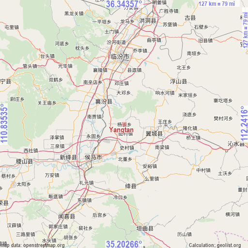
Yangtan GPS coordinates[2]
35° 46' 30.576" North, 111° 32' 18.492" East
| Map corner | latitude | longitude |
|---|---|---|
| Upper-left | 36.34357°, | 110.83535° |
| Center: | 35.77516°, | 111.53847° |
| Lower-right: | 35.20266°, | 112.2416° |
| Map W x H: | 126.9×126.9 km | = 78.9×78.9mi |
| max Lat: | 53.31946° ⇑23.3% North |
| Yangtan: | 35.77516° |
| min Lat: | ⇓76.7% South 18.22056° |
| min Long | Yangtan | max Long |
| 75.07348° | 111.53847° | 134.28917° |
| W 35.1%⇐ | ⇒64.9% E |
Elevation
Elevation of Yangtan is 565 m = 1854 ft, and this is 80.2 m = 263 ft above average elevation for this country.
| Max E: |
5622 m = 18445 ft | 23.4% |
| Yangtan | 565 m 1854 ft | |
| Avg. | 484.8 m = 1591 ft | |
Min E: |
-3 m = -10 ft | 76.6% |
See also: China elevation on elevation.city.
Geographical zone
Yangtan is located in North temperate zone (between Tropic of Cancer and the Arctic Circle). Distance of this Northern Tropic circle is 1371.9 km =852.5 mi to South.| Distance of | km | miles | from Yangtan |
|---|---|---|---|
| North Pole | 6029.2 | 3746.4 | to North |
| Arctic Circle | 3423.3 | 2127.1 | to North |
| Tropic Cancer | 1371.9 | 852.5 | to South |
| Equator | 3977.8 | 2471.7 | to South |


Nearby cities:
15 places around Yangtan: (largest is in red/bold)
• Beidong
17.7 km =11 mi,  178°
178°
• Dadeng
16.3 km =10.1 mi,  358°
358°
• Dengzhuang
21.1 km =13.1 mi, 356°
• Fengcheng
18.3 km =11.4 mi,  210°
210°
• Gaoxian
12.3 km =7.6 mi,  239°
239°
• Jingmao
20.3 km =12.6 mi,  305°
305°
• Lechang
16.1 km =10 mi,  203°
203°
• Licun
7.7 km =4.8 mi,  258°
258°
• Nanjia
16 km =9.9 mi,  284°
284°
• Qucun
4.7 km =2.9 mi,  172°
172°
• Tangxing
14.8 km =9.2 mi,  102°
102°
• Taosi
14 km =8.7 mi,  345°
345°
• Xijia
19.6 km =12.2 mi, 280°
• Xincheng
14.5 km =9 mi,  320°
320°
• Yonggu
16.9 km =10.5 mi,  249°
249°
Sources, notices
• [Note1] Compared only with cities in China existing in our database
• [Src1] Map data: © OpenStreetMap contributors (CC-BY-SA)
• [Src2] Other city data from geonames.org with taken over terms of usage.
• [Src3] Geographical zone / Annual Mean Temperature by Robert A. Rohde @ Wikipedia
