Nanjia geodata
Nanjia (Shanxi) is a seat of a fourth-order administrative division; located in China in Asia/Shanghai (GMT+8) time zone. In our database, there are 1268 cities with bigger population. Compared to other cities in China, 76.8% of cities are located further ↓South; 65.6% of cities are located further →East and 75.3% of cities have lower elevation than Nanjia. Note1


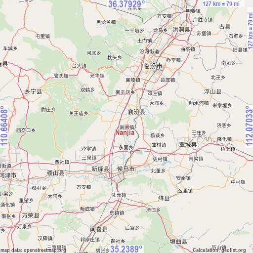
Nanjia GPS coordinates[2]
35° 48' 40.104" North, 111° 22' 1.92" East
| Map corner | latitude | longitude |
|---|---|---|
| Upper-left | 36.37929°, | 110.66408° |
| Center: | 35.81114°, | 111.3672° |
| Lower-right: | 35.2389°, | 112.07033° |
| Map W x H: | 126.8×126.8 km | = 78.8×78.8mi |
| max Lat: | 53.31946° ⇑23.2% North |
| Nanjia: | 35.81114° |
| min Lat: | ⇓76.8% South 18.22056° |
| min Long | Nanjia | max Long |
| 75.07348° | 111.3672° | 134.28917° |
| W 34.4%⇐ | ⇒65.6% E |
Elevation
Elevation of Nanjia is 529 m = 1736 ft, and this is 44.2 m = 145 ft above average elevation for this country.
| Max E: |
5622 m = 18445 ft | 24.7% |
| Nanjia | 529 m 1736 ft | |
| Avg. | 484.8 m = 1591 ft | |
Min E: |
-3 m = -10 ft | 75.3% |
See also: China elevation on elevation.city.
Geographical zone
Nanjia is located in North temperate zone (between Tropic of Cancer and the Arctic Circle). Distance of this Northern Tropic circle is 1375.9 km =854.9 mi to South.| Distance of | km | miles | from Nanjia |
|---|---|---|---|
| North Pole | 6025.2 | 3743.9 | to North |
| Arctic Circle | 3419.3 | 2124.7 | to North |
| Tropic Cancer | 1375.9 | 854.9 | to South |
| Equator | 3981.8 | 2474.2 | to South |


Nearby cities:
15 places around Nanjia: (largest is in red/bold)
• Dadeng
19.4 km =12.1 mi,  50°
50°
• Fencheng
8.4 km =5.2 mi,  274°
274°
• Gaoxian
11.3 km =7 mi,  154°
154°
• Gucheng
12 km =7.5 mi,  338°
338°
• Jingmao
7.9 km =4.9 mi,  352°
352°
• Licun
9.7 km =6 mi,  125°
125°
• Nanxindian
17.6 km =10.9 mi,  357°
357°
• Qucun
18.2 km =11.3 mi,  118°
118°
• Taosi
15.2 km =9.4 mi, 51°
• Xijia
3.8 km =2.4 mi, 265°
• Xincheng
9.4 km =5.8 mi,  40°
40°
• Yangtan
16 km =9.9 mi,  104°
104°
• Yonggu
10 km =6.2 mi,  182°
182°
• Zhangcun
18 km =11.2 mi,  185°
185°
• Zhaokang
14.8 km =9.2 mi,  227°
227°
Sources, notices
• [Note1] Compared only with cities in China existing in our database
• [Src1] Map data: © OpenStreetMap contributors (CC-BY-SA)
• [Src2] Other city data from geonames.org with taken over terms of usage.
• [Src3] Geographical zone / Annual Mean Temperature by Robert A. Rohde @ Wikipedia
