Yanglinshi geodata
Yanglinshi (Hubei) is a seat of a fourth-order administrative division; located in China in Asia/Shanghai (GMT+8) time zone. In our database, there are 1268 cities with bigger population. Compared to other cities in China, 54.3% of cities are located further ↑North; 63.6% of cities are located further →East and 69.2% of cities have higher elevation than Yanglinshi. Note1


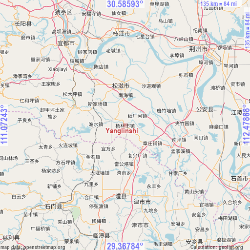
Yanglinshi GPS coordinates[2]
29° 58' 43.5" North, 111° 46' 31.98" East
| Map corner | latitude | longitude |
|---|---|---|
| Upper-left | 30.58593°, | 111.07243° |
| Center: | 29.97875°, | 111.77555° |
| Lower-right: | 29.36784°, | 112.47868° |
| Map W x H: | 135.4×135.4 km | = 84.1×84.1mi |
| max Lat: | 53.31946° ⇑54.3% North |
| Yanglinshi: | 29.97875° |
| min Lat: | ⇓45.7% South 18.22056° |
| min Long | Yanglinshi | max Long |
| 75.07348° | 111.77555° | 134.28917° |
| W 36.4%⇐ | ⇒63.6% E |
Elevation
Elevation of Yanglinshi is 55 m = 180 ft, and this is 429.8 m = 1410 ft below average elevation for this country.
| Max E: |
5622 m = 18445 ft | 69.2% |
| Avg. | 484.8 m = 1591 ft | |
| Yanglinshi | 55 m = 180 ft | |
Min E: |
-3 m = -10 ft | 30.8% |
See also: China elevation on elevation.city.
Geographical zone
Yanglinshi is located in North temperate zone (between Tropic of Cancer and the Arctic Circle). Distance of this Northern Tropic circle is 727.4 km =452 mi to South.| Distance of | km | miles | from Yanglinshi |
|---|---|---|---|
| North Pole | 6673.7 | 4146.8 | to North |
| Arctic Circle | 4067.8 | 2527.6 | to North |
| Tropic Cancer | 727.4 | 452 | to South |
| Equator | 3333.3 | 2071.2 | to South |


Nearby cities:
15 places around Yanglinshi: (largest is in red/bold)
• Banzhudang
23.8 km =14.8 mi,  69°
69°
• Fuxingchang
17.4 km =10.8 mi,  157°
157°
• Jieheshi
7 km =4.3 mi,  303°
303°
• Leigongta
20.7 km =12.9 mi,  181°
181°
• Nanhai
16.6 km =10.3 mi,  0°
0°
• Shizikou
22.9 km =14.2 mi,  87°
87°
• Shuanglong
21.3 km =13.2 mi,  146°
146°
• Sijiachang
19 km =11.8 mi,  308°
308°
• Wangjiaqiao
20.1 km =12.5 mi,  329°
329°
• Wanjia
7.8 km =4.8 mi,  261°
261°
• Weishui
15.8 km =9.8 mi,  273°
273°
• Yanjing
15.2 km =9.4 mi,  185°
185°
• Yiwan
15.4 km =9.6 mi,  216°
216°
• Zhangzhuangpu
17.6 km =10.9 mi,  122°
122°
• Zhichanghe
8.6 km =5.3 mi,  50°
50°
Sources, notices
• [Note1] Compared only with cities in China existing in our database
• [Src1] Map data: © OpenStreetMap contributors (CC-BY-SA)
• [Src2] Other city data from geonames.org with taken over terms of usage.
• [Src3] Geographical zone / Annual Mean Temperature by Robert A. Rohde @ Wikipedia
