Nanhai geodata
Nanhai (Hubei) is a seat of a fourth-order administrative division; located in China in Asia/Shanghai (GMT+8) time zone. In our database, there are 1268 cities with bigger population. Compared to other cities in China, 52.8% of cities are located further ↑North; 63.6% of cities are located further →East and 67.4% of cities have higher elevation than Nanhai. Note1


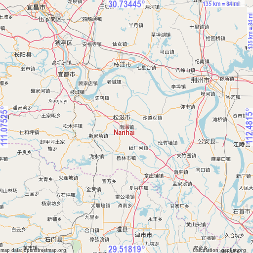
Nanhai GPS coordinates[2]
30° 7' 41.484" North, 111° 46' 42.132" East
| Map corner | latitude | longitude |
|---|---|---|
| Upper-left | 30.73445°, | 111.07525° |
| Center: | 30.12819°, | 111.77837° |
| Lower-right: | 29.51819°, | 112.4815° |
| Map W x H: | 135.2×135.2 km | = 84×84mi |
| max Lat: | 53.31946° ⇑52.8% North |
| Nanhai: | 30.12819° |
| min Lat: | ⇓47.2% South 18.22056° |
| min Long | Nanhai | max Long |
| 75.07348° | 111.77837° | 134.28917° |
| W 36.4%⇐ | ⇒63.6% E |
Elevation
Elevation of Nanhai is 63 m = 207 ft, and this is 421.8 m = 1384 ft below average elevation for this country.
| Max E: |
5622 m = 18445 ft | 67.4% |
| Avg. | 484.8 m = 1591 ft | |
| Nanhai | 63 m = 207 ft | |
Min E: |
-3 m = -10 ft | 32.6% |
See also: China elevation on elevation.city.
Geographical zone
Nanhai is located in North temperate zone (between Tropic of Cancer and the Arctic Circle). Distance of this Northern Tropic circle is 744 km =462.3 mi to South.| Distance of | km | miles | from Nanhai |
|---|---|---|---|
| North Pole | 6657.1 | 4136.5 | to North |
| Arctic Circle | 4051.2 | 2517.3 | to North |
| Tropic Cancer | 744 | 462.3 | to South |
| Equator | 3349.9 | 2081.5 | to South |


Nearby cities:
15 places around Nanhai: (largest is in red/bold)
• Babao
10.7 km =6.6 mi,  55°
55°
• Banzhudang
23.6 km =14.7 mi,  110°
110°
• Chendian
20.3 km =12.6 mi,  319°
319°
• Jieheshi
14.2 km =8.8 mi,  205°
205°
• Laocheng
25 km =15.5 mi,  344°
344°
• Maojiagang
29.5 km =18.3 mi, 108°
• Shadaoguan
14.7 km =9.1 mi,  70°
70°
• Shizikou
27.5 km =17.1 mi,  124°
124°
• Sijiachang
15.8 km =9.8 mi,  252°
252°
• Songmuping
28.8 km =17.9 mi,  271°
271°
• Wangjiaqiao
10.3 km =6.4 mi, 274°
• Wanjia
19.5 km =12.1 mi,  204°
204°
• Weishui
22.5 km =14 mi,  225°
225°
• Yanglinshi
16.6 km =10.3 mi,  180°
180°
• Zhichanghe
12.8 km =8 mi,  150°
150°
Sources, notices
• [Note1] Compared only with cities in China existing in our database
• [Src1] Map data: © OpenStreetMap contributors (CC-BY-SA)
• [Src2] Other city data from geonames.org with taken over terms of usage.
• [Src3] Geographical zone / Annual Mean Temperature by Robert A. Rohde @ Wikipedia
