Yabai geodata
Yabai (Shaanxi) is a seat of a fourth-order administrative division; located in China in Asia/Shanghai (GMT+8) time zone. In our database, there are 1268 cities with bigger population. Compared to other cities in China, 71% of cities are located further ↓South; 80.2% of cities are located further →East and 71.9% of cities have lower elevation than Yabai. Note1


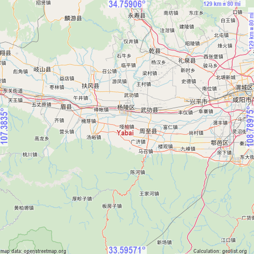
Yabai GPS coordinates[2]
34° 10' 45.804" North, 108° 5' 11.832" East
| Map corner | latitude | longitude |
|---|---|---|
| Upper-left | 34.75906°, | 107.3835° |
| Center: | 34.17939°, | 108.08662° |
| Lower-right: | 33.59571°, | 108.78975° |
| Map W x H: | 129.4×129.4 km | = 80.4×80.4mi |
| max Lat: | 53.31946° ⇑29% North |
| Yabai: | 34.17939° |
| min Lat: | ⇓71% South 18.22056° |
| min Long | Yabai | max Long |
| 75.07348° | 108.08662° | 134.28917° |
| W 19.8%⇐ | ⇒80.2% E |
Elevation
Elevation of Yabai is 451 m = 1480 ft, and this is 33.8 m = 111 ft below average elevation for this country.
| Max E: |
5622 m = 18445 ft | 28.1% |
| Avg. | 484.8 m = 1591 ft | |
| Yabai | 451 m = 1480 ft | |
Min E: |
-3 m = -10 ft | 71.9% |
See also: China elevation on elevation.city.
Geographical zone
Yabai is located in North temperate zone (between Tropic of Cancer and the Arctic Circle). Distance of this Northern Tropic circle is 1194.5 km =742.2 mi to South.| Distance of | km | miles | from Yabai |
|---|---|---|---|
| North Pole | 6206.7 | 3856.7 | to North |
| Arctic Circle | 3600.8 | 2237.4 | to North |
| Tropic Cancer | 1194.5 | 742.2 | to South |
| Equator | 3800.4 | 2361.5 | to South |


Nearby cities:
15 places around Yabai: (largest is in red/bold)
• Daijia
18.3 km =11.4 mi,  18°
18°
• Dazhuang
10.8 km =6.7 mi,  40°
40°
• Erqu
11.4 km =7.1 mi,  105°
105°
• Guangji
8.8 km =5.5 mi,  140°
140°
• Hengqu
11.8 km =7.3 mi,  279°
279°
• Houjia
8.8 km =5.5 mi,  100°
100°
• Jiangzhang
17.6 km =10.9 mi,  300°
300°
• Mazhaozhen
15.4 km =9.6 mi, 141°
• Pujijie
15.8 km =9.8 mi,  67°
67°
• Qinghua
5.4 km =3.4 mi, 275°
• Wugong
14.1 km =8.8 mi,  51°
51°
• Wugong
16.7 km =10.4 mi,  6°
6°
• Wuquan
16 km =9.9 mi,  327°
327°
• Yangling
10.3 km =6.4 mi,  356°
356°
• Zhuyu
6.5 km =4 mi,  221°
221°
Sources, notices
• [Note1] Compared only with cities in China existing in our database
• [Src1] Map data: © OpenStreetMap contributors (CC-BY-SA)
• [Src2] Other city data from geonames.org with taken over terms of usage.
• [Src3] Geographical zone / Annual Mean Temperature by Robert A. Rohde @ Wikipedia
